Old Milestone by Cirencester Road, Minchinhampton parish
Introduction
The photograph on this page of Old Milestone by Cirencester Road, Minchinhampton parish by M Faherty as part of the Geograph project.
The Geograph project started in 2005 with the aim of publishing, organising and preserving representative images for every square kilometre of Great Britain, Ireland and the Isle of Man.

There are currently over 7.5m images from over 14,400 individuals and you can help contribute to the project by visiting https://www.geograph.org.uk
Old Milestone by Cirencester Road, Minchinhampton parish
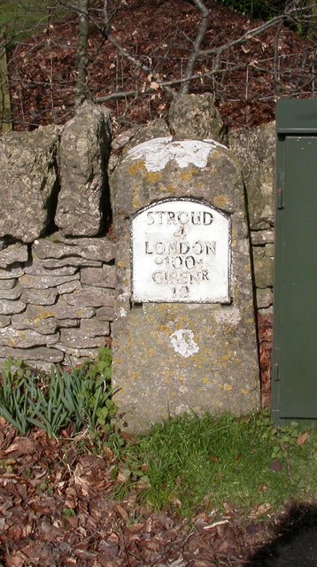
Image: © M Faherty Taken: 13 Mar 2011
Metal plate attached to stone post by the UC road, in parish of MINCHINHAMPTON (STROUD District), Cirencester Road; beside green fuse box; 50m West of Burleigh Court turn, on the verge under trees, on North side of road. Cirencester roundhead iron plate, erected by the Cirencester to Stroud turnpike trust in the 19th century. Inscription reads:- STROUD 4 LONDON 100 CIRENR 10 Grade II listed. List Entry Number: 1340455 https://historicengland.org.uk/listing/the-list/list-entry/1340455 Milestone Society National ID: GL_CISD10.
Images are licensed for reuse under creativecommons.org/licenses/by-sa/2.0
Image Location
Latitude
51.709917
Longitude
-2.192368