Old Milestone by the A205, Upper Richmond Road, Roehampton
Introduction
The photograph on this page of Old Milestone by the A205, Upper Richmond Road, Roehampton by L Joseph as part of the Geograph project.
The Geograph project started in 2005 with the aim of publishing, organising and preserving representative images for every square kilometre of Great Britain, Ireland and the Isle of Man.

There are currently over 7.5m images from over 14,400 individuals and you can help contribute to the project by visiting https://www.geograph.org.uk
Old Milestone by the A205, Upper Richmond Road, Roehampton
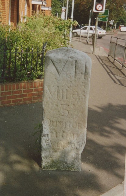
Image: © L Joseph Taken: Unknown
Carved stone post by the A205, in parish of RICHMOND UPON THAMES (RICHMOND UPON THAMES District), Upper Richmond Road, Roehampton, in pavement by junction and pedestrian lights. It was by the wall of the Red Rover Inn (now gone) with glass panel so the rear face of the stone was visible from gardens, on North side of road. Surrey limestone pillar, erected by the Surrey & Sussex turnpike trust in the 18th century. Inscription reads:- : V / Miles / 3 / Quarters / from / Hyde / (Park / Corner) : : IX / Miles / from the / Standard / in / Cornhill : : VII / Miles / 3 Quarters from / Hampton / Court / BARNES PARISH : Listed, List Entry Number:1254253 https://historicengland.org.uk/listing/the-list/list-entry/1254253 Milestone Society National ID: SY_LSS09.
Images are licensed for reuse under creativecommons.org/licenses/by-sa/2.0
Image Location
Latitude
51.465336
Longitude
-0.244305