Old Milestone by the A635, Wilthorpe Road, Wilthorpe
Introduction
The photograph on this page of Old Milestone by the A635, Wilthorpe Road, Wilthorpe by C Minto as part of the Geograph project.
The Geograph project started in 2005 with the aim of publishing, organising and preserving representative images for every square kilometre of Great Britain, Ireland and the Isle of Man.

There are currently over 7.5m images from over 14,400 individuals and you can help contribute to the project by visiting https://www.geograph.org.uk
Old Milestone by the A635, Wilthorpe Road, Wilthorpe
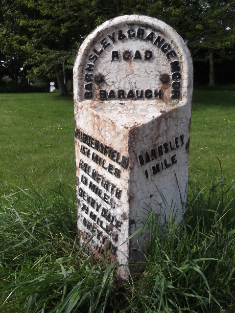
Image: © C Minto Taken: 1 Dec 2001
Metal plate attached to stone post by the A635, in parish of BARNSLEY (BARNSLEY District), Wilthorpe Road, 150m West of Rowland Road, on the verge, near Innovation Way, on South side of road. Brayshaw & Booth iron casting, erected by the County Council in the 19th century. Inscription reads:- : HUDDERSFIELD / 15¼ MILES / HOLMFIRTH / 13 MILES / DENBY DALE / 7¼ MILES / BRETTON / 5½ MILES / CAWTHORNE / 2 MILES : : BARNSLEY & GRANGE MOOR / ROAD / BARAUGH : : BARNSLEY / 1 MILE : Maker:- : BRAYSHAW & BOOTH / MAKERS / LIVERSEDGE : Carved benchmark on left side. Grade II listed. List Entry Number: 1151771 https://historicengland.org.uk/listing/the-list/list-entry/1151771 Milestone Society National ID: YS_BNHU01.
Images are licensed for reuse under creativecommons.org/licenses/by-sa/2.0
Image Location
Latitude
53.565327
Longitude
-1.502319