Clacton-on-Sea: Martello Tower E
Introduction
The photograph on this page of Clacton-on-Sea: Martello Tower E by Nigel Cox as part of the Geograph project.
The Geograph project started in 2005 with the aim of publishing, organising and preserving representative images for every square kilometre of Great Britain, Ireland and the Isle of Man.

There are currently over 7.5m images from over 14,400 individuals and you can help contribute to the project by visiting https://www.geograph.org.uk
Clacton-on-Sea: Martello Tower E
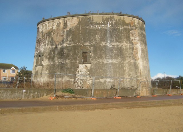
Image: © Nigel Cox Taken: 28 Oct 2018
The east coast Martello Towers were built between 1808 and 1812. 29 were built from St Osyth in Essex north-eastwards to Aldeburgh in Suffolk, and are named by Historic England in the same order from A to Z then AA to CC, so this is the fifth tower along. Just to confuse the issue the Ordnance Survey refer to this one as Tower No 2 on all their mapping. The east coast towers are not circular in plan nor oval as might be thought from this viewpoint, but more of a triangular ovoid for want of a better term. This one is a Scheduled Monument and a Grade II Listed Building and the Historic England website describes it quite briefly thus:- "Martello Tower adjacent to sea wall, Butlins Holiday Village. Vari-coloured brick, made at Grays, Essex, now rendered. Stone parapet. Rusticated stone dressings to 4 windows and door at half height. Built at a cost of approximately £5,000." The Butlin's Holiday Camp has long been demolished, but the 1955 large scale Ordnance Survey maps show the tower completely surrounded by the camp. Interestingly the Victorian Ordnance Survey large scale maps do not show these towers at all, just the boundary lines of the plots, so evidently they were considered to be of military significance long after the threat of a Napoleonic invasion had passed. This one is evidently in a dangerous state and a half-hearted attempt has been made to keep the hoi polloi out with some fairly rickety Heras fencing. The Ordnance Survey records also show that there is a 4th Order Triangulation Station, a bolt, set somewhere on the roof. This would have served the same purpose as the more familiar triangulation pillars, as being a point that had been very accurately co-ordinated to the mapping grid of the time. The OS records also state that it was last maintained in 1959, and that since the tower was bricked up, a very long ladder was required to access the roof!
Images are licensed for reuse under creativecommons.org/licenses/by-sa/2.0
Image Location
Latitude
51.780431
Longitude
1.140239