WWII Shropshire: RAF Rednal - Control Tower (13)
Introduction
The photograph on this page of WWII Shropshire: RAF Rednal - Control Tower (13) by Mike Searle as part of the Geograph project.
The Geograph project started in 2005 with the aim of publishing, organising and preserving representative images for every square kilometre of Great Britain, Ireland and the Isle of Man.

There are currently over 7.5m images from over 14,400 individuals and you can help contribute to the project by visiting https://www.geograph.org.uk
WWII Shropshire: RAF Rednal - Control Tower (13)
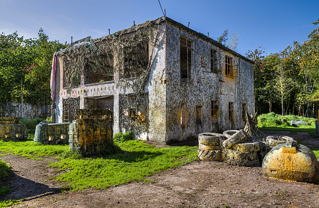
Image: © Mike Searle Taken: 28 Sep 2017
- The wartime airfield Type 518/40 control tower or Watch Office with meteorological section, is extant and in use today as one of several battlefield buildings on a paintball site. The large lower floor housed the Watch Office and the Meteorological Office, while the upper floor housed the Airfield Control Office. There was also access to the roof from the upper floor. RAF Rednal was opened in April 1942 as a standard fighter OTU with a satellite airfield at Montford Bridge https://www.geograph.org.uk/photo/6205287 near Shrewsbury. No. 61 OTU were based here for the duration flying Miles Masters and old Spitfires that had survived the Battle of Britain. Not surprisingly with young student pilots, old aircraft, and the adjacent Shropshire hills, the accident rate was high, with many being killed or injured during their training. I am also reliably informed that later in the war pilots received conversion training on Mustang fighters at Rednal, a number of whom were Polish. When No. 61 OTU moved out in June 1945, the airfield was placed under care and maintenance shortly after, until such time as it was sold in 1962. Image
Images are licensed for reuse under creativecommons.org/licenses/by-sa/2.0
Image Location
Latitude
52.842111
Longitude
-2.937661