Display Board on Ley Hill Common
Introduction
The photograph on this page of Display Board on Ley Hill Common by David Hillas as part of the Geograph project.
The Geograph project started in 2005 with the aim of publishing, organising and preserving representative images for every square kilometre of Great Britain, Ireland and the Isle of Man.

There are currently over 7.5m images from over 14,400 individuals and you can help contribute to the project by visiting https://www.geograph.org.uk
Display Board on Ley Hill Common
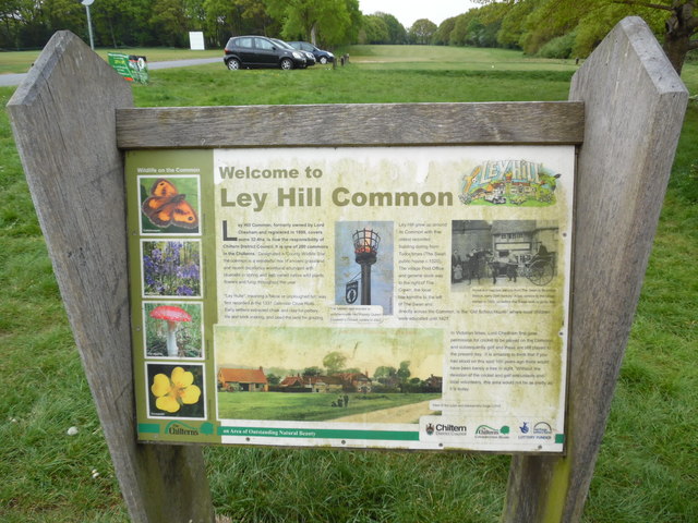
Image: © David Hillas Taken: 11 May 2017
This photo shows the display board at the West end of Leyhill Common and has the following wording on it: Welcome to Ley Hill Common Ley Hill Common, formerly owned by Lord Chesham and registered in 1899, covers some 32.4ha, is now the responsibility of Chiltern District Council. It is one of 200 commons in the Chilterns. Designated a "County Wildlife Site", the common is a wonderful mix of ancient grassland and recent deciduous woodland abundant with bluebells in spring and with varied native wild plants, flowers and fungi throughout the year. "Ley Hulle" meaning a fallow or unploughed hill, was first recorded in the 1337 Calendar Close Rolls. Early settlers extracted chalk and clay for pottery, tile and brick making, and used the land for grazing. Ley Hill grew up around its Common with the oldest recorded building dating from Tudor times (The Swan public house c.1520). The village Post Office and general store was to the right of The Crown, the local blacksmiths to the left of The Swan and, directly across the Common, is the "Old School House" where local children were educated until 1927. In Victorian times, Lord Chesham first gave permission for cricket to be played on the Common and subsequently golf and these are still played to the present day. It is amazing to think that if you had stood on this spot 100 years ago there would have been barely a tree in sight. Without the devotion of the cricket and golf enthusiasts and local volunteers, this area would not be as pretty as it is today. The pictures on the left are from top to bottom: Gatekeeper butterfly, Bluebells, Fly Agaric mushroom and Tormentil perennial plant. In the middle is a picture of the beacon that was erected to commemorate Her Majesty Queen Elizabeth's Golden Jubilee in 2002. To the right is a photo of a horse and trap taxi service from The Swan to Boxmoor Station, early 20th century. A bus service to the village started in 1925, so before that it was walk or go by trap. The bottom picture is a view of the pubs and blacksmiths forge c.1910. Incidentally, 32.4ha (or hectares) mentioned in the description above, corresponds to 80 acres.
Images are licensed for reuse under creativecommons.org/licenses/by-sa/2.0
Image Location
Latitude
51.707383
Longitude
-0.568644