Lost pubs of Annetwell Street - June 2017
Introduction
The photograph on this page of Lost pubs of Annetwell Street - June 2017 by The Carlisle Kid as part of the Geograph project.
The Geograph project started in 2005 with the aim of publishing, organising and preserving representative images for every square kilometre of Great Britain, Ireland and the Isle of Man.

There are currently over 7.5m images from over 14,400 individuals and you can help contribute to the project by visiting https://www.geograph.org.uk
Lost pubs of Annetwell Street - June 2017
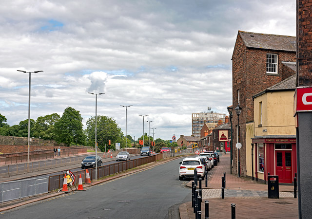
Image: © The Carlisle Kid Taken: 25 Jun 2017
Before 1916, there were two pubs on the left in this view - closest to the camera was the Saracen's Head (also known as the Saracen's Head Hotel), which probably dated from the early years of the 19th Century. Next to it, a little beyond the traffic cones, was the Black Bull Vaults (also known as the Black Bull Hotel or the Old Black Bull), which also dated from the early 19th Century. Both pubs were acquired by the State Management Scheme, the Saracen's Head on 4 August 1916 and the Black Bull on 23 August 1916 - both were almost immediately closed as the Scheme planned a "super pub" on the site, which was achieved by knocking down the partition wall between the two pubs. The re-named Irish Gate Tavern opened in October 1917. The entire north side of Annetwell Street was demolished 1972/73 to make way for Castle Way, Carlisle's inner ring-road scheme, and consequently all trace of the pubs has been obliterated. A 1902 photograph of the Black Bull can be viewed: http://www.closedpubs.co.uk/cumberland/carlisle_irishgatetavern.html
Images are licensed for reuse under creativecommons.org/licenses/by-sa/2.0
Image Location


Leaflet Map data © OpenStreetMap
Latitude
54.895613
Longitude
-2.942194