"The Beacon Stones" and anchor
Introduction
The photograph on this page of "The Beacon Stones" and anchor by Adrian S Pye as part of the Geograph project.
The Geograph project started in 2005 with the aim of publishing, organising and preserving representative images for every square kilometre of Great Britain, Ireland and the Isle of Man.

There are currently over 7.5m images from over 14,400 individuals and you can help contribute to the project by visiting https://www.geograph.org.uk
"The Beacon Stones" and anchor
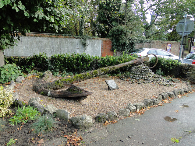
Image: © Adrian S Pye Taken: 20 Oct 2010
The anchor is resting on what appears to be just a heap of stones but the small circular plaque which is barely legible tells a different story. i.e. "The Beacon Stones" these are said to be the base of a warning beacon against coastal attack erected in 1550 on the order of the Marquis of Northampton. Why the Marquis made such an order is unclear as at that time there was no immediate threat from the French and the Spanish were busy invading South America. Of course it could always be something else entirely as such stories are often assumed or fabricated when 'experts' haven't got a clue as to its original purpose, if in fact it ever had one. The more likely story is that these are "The Witches' Stones" which at the first stroke of midnight on the town hall clock make their way to the sea for a drink before returning by the twelfth stroke. If however water is poured upon them it causes it to rain and they have no need to go to the sea for a drink but can happily stay where they are supporting the anchor.
Images are licensed for reuse under creativecommons.org/licenses/by-sa/2.0
Image Location
Latitude
52.487605
Longitude
1.755087