Main Street, Belton, Lincs.
Introduction
The photograph on this page of Main Street, Belton, Lincs. by David Hallam-Jones as part of the Geograph project.
The Geograph project started in 2005 with the aim of publishing, organising and preserving representative images for every square kilometre of Great Britain, Ireland and the Isle of Man.

There are currently over 7.5m images from over 14,400 individuals and you can help contribute to the project by visiting https://www.geograph.org.uk
Main Street, Belton, Lincs.
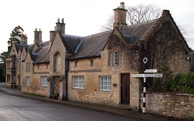
Image: © David Hallam-Jones Taken: 26 Dec 2015
The nearest building faces a T junction and overlooks the road to Barkston Heath. It is a Grade-II listed former coach house and stable block dating from 1763, although now it is a private house. The stable block is behind the property and is accessed through an arched entrance further along this row. The property furthest away (i.e. along the A607 in the direction of Belton House) is a Grade-II listed C15th former public house originally known as The Greyhound Inn that is now a private house.
Images are licensed for reuse under creativecommons.org/licenses/by-sa/2.0
Image Location
Latitude
52.946358
Longitude
-0.616645