New Kilpatrick Cemetery: base of the Antonine Wall
Introduction
The photograph on this page of New Kilpatrick Cemetery: base of the Antonine Wall by Lairich Rig as part of the Geograph project.
The Geograph project started in 2005 with the aim of publishing, organising and preserving representative images for every square kilometre of Great Britain, Ireland and the Isle of Man.

There are currently over 7.5m images from over 14,400 individuals and you can help contribute to the project by visiting https://www.geograph.org.uk
New Kilpatrick Cemetery: base of the Antonine Wall
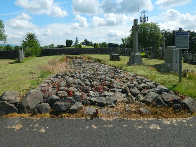
Image: © Lairich Rig Taken: 3 Jul 2015
This is the more easterly of the two preserved sections of the stone base of the Antonine Wall that are on view in New Kilpatrick Cemetery. For the westerly one, see Image, and other images that are linked from there. As for this eastern section, it is almost 30 metres long; as the picture shows, there is a distinct kerb on each side. Compare Image, a view from a different angle, highlighting the southern curbstones. For a view from the other end, see Image Like the other section, this easterly one is crossed obliquely by an original culvert, whose remains are visible: Image The wall that can be seen not far ahead in the present picture is the eastern boundary of the cemetery; there is a golf course on the other side. The cross to the right of the Wall's base is the Cuthbert Memorial. Beyond that is a table stone commemorating Sir Archibald Spencer Lindsey Campbell, the Fifth Baronet of Succoth, and his wife. For another contributor's earlier picture of the Wall's stone base, from this end, see Image
Images are licensed for reuse under creativecommons.org/licenses/by-sa/2.0
Image Location
Latitude
55.922887
Longitude
-4.310197