Ridge and furrow, and wardling(?) on fields along Billings Gate, South Somercotes (aerial 2015)
Introduction
The photograph on this page of Ridge and furrow, and wardling(?) on fields along Billings Gate, South Somercotes (aerial 2015) by Chris as part of the Geograph project.
The Geograph project started in 2005 with the aim of publishing, organising and preserving representative images for every square kilometre of Great Britain, Ireland and the Isle of Man.

There are currently over 7.5m images from over 14,400 individuals and you can help contribute to the project by visiting https://www.geograph.org.uk
Ridge and furrow, and wardling(?) on fields along Billings Gate, South Somercotes (aerial 2015)
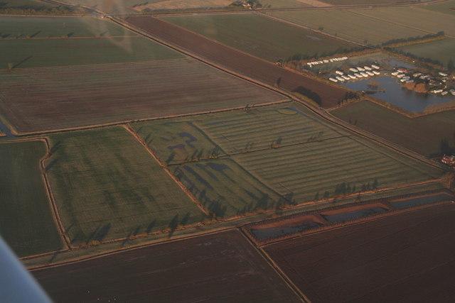
Image: © Chris Taken: 22 Feb 2015
I had been bemoaning my fate, the shrill cry of the alarm clock - but some spectacular vistas, and it is well over an hour before I can bring myself to return to the airfield. It is early on a February morning, long shadows and the frost show up the ridge and furrow and the marks of old hedge and ditch lines in the grass. "February fill-dike" and many local fields are flooded. However this looks as if the centre fields may have had some encouragement: there is a recent trend in this area to create linear ponds for wildlife, often along old dike or furrow lines. At Middlemarsh Farm, Burgh le Marsh this has been named "Wardling" after Roger Wardle who championed it there. For aerial films of this area see: https://www.youtube.com/watch?v=wwhVamd4j6E and https://www.youtube.com/watch?v=zZjqzcMFXi8 These are LiDAR films of the Wolds and Marshes east of Louth. The films are narrated by Jim Broadbent. The land is colour-coded according to its elevation. The films show how the landscape was reclaimed for salt making and grazing. Footage includes ancient river systems, settlements, salterns and ridge and furrow. Produced for the Lincolnshire Coastal Grazing Marshes Project, which has now terminated.
Images are licensed for reuse under creativecommons.org/licenses/by-sa/2.0
Image Location


Leaflet Map data © OpenStreetMap
Latitude
53.42871
Longitude
0.145996