The Grave of Old King Cole
Introduction
The photograph on this page of The Grave of Old King Cole by Mary and Angus Hogg as part of the Geograph project.
The Geograph project started in 2005 with the aim of publishing, organising and preserving representative images for every square kilometre of Great Britain, Ireland and the Isle of Man.

There are currently over 7.5m images from over 14,400 individuals and you can help contribute to the project by visiting https://www.geograph.org.uk
The Grave of Old King Cole
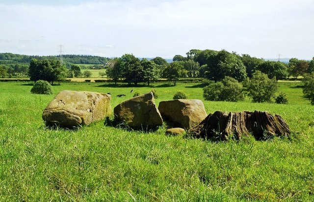
Image: © Mary and Angus Hogg Taken: 6 Jun 2014
King Coil’s Grave is a low mound about 15 metres wide at Coilsfield Mains Farm, near Tarbolton. The site was excavated in 1837, revealing piles of bones, pieces of armour and clay urns containing bone ash. Two whinstone boulders lie on the top, one of which has split into two pieces. Very old stumps show that the site was marked by trees. For information about the site, see http://canmore.rcahms.gov.uk/en/site/42711/details/coilsfield+mains+king+coil+s+grave/&biblio=more The authenticity of this site as the grave of Old King Cole cannot be proved but the Irish warrior Coilus, King of the Britons, did rule the south-west of Scotland, frequently fighting the Picts and the Scots. Coilus met his death in a battle somewhere in modern-day South Ayrshire, near the River Ayr. The Picts and the Scots had combined forces against their hated enemy and, attacking under the cover of darkness, killed all the Britons in the conflict. The contents of the mound and local place names of “Bloody Burn” and “Dead Men’s Holm” suggest that the Tarbolton site is authentic. As a warrior king and worthy opponent, Coilus would have been considered deserving of a proper burial. For historical information, see http://www.discoverayrshire.co.uk/history_old-king-coil.html
Images are licensed for reuse under creativecommons.org/licenses/by-sa/2.0
Image Location


Leaflet Map data © OpenStreetMap
Latitude
55.505166
Longitude
-4.460814