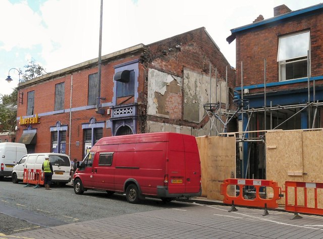
Site of Kenworthy's Jewellers
Introduction
The photograph on this page of Site of Kenworthy's Jewellers by Gerald England as part of the Geograph project.
The Geograph project started in 2005 with the aim of publishing, organising and preserving representative images for every square kilometre of Great Britain, Ireland and the Isle of Man.
There are currently over 7.5m images from over 14,400 individuals and you can help contribute to the project by visiting https://www.geograph.org.uk

Image: © Gerald England Taken: 9 May 2014
Site of a building on Stamford Street Central (formerly Kenworthy's Jewellers) that collapsed on 27th March 2014. According to the Manchester Evening News report: http://www.manchestereveningnews.co.uk/news/greater-manchester-news/dramatic-video-shows-moment-dangerous-6885760 police were called out to the property at 7.30am following reports of falling bricks and debris. Officers quickly decided to cordon off the two-storey building beside Universal nightclub and close a section of the road between Oldham Road and Booth Street after it appeared the building had bowed and was in imminent danger of collapse. It collapsed shortly after noon. Eye-witnesses described how a man who was standing on the cradle of a cherry picker had just removed a single brick when it came down. The collapse was captured on video by Vanessa Dixon and can be viewed on YouTube https://www.youtube.com/watch?v=dASezMi9NBY The Institution of Structural Engineers issued a statement (link no longer available) "Clearly, from what we have seen of the footage, the building was in a very severe state. We could see cracking and bowing in panels of brickwork between the windows and we could also see a crack above where the shop window would have been. That could indicate that the beam supporting the brickwork had partially broken. The worker on the cherrypicker in the video should certainly not have pried at this delicate structure with a crowbar in the way he did. If a structural engineer had been consulted appropriately the building could potentially have been saved or a safe demolition could have been determined and carried out." A blue plaque mounted on the front of the building marked the fact it was once home to poet Francis Thompson http://www.ashton-under-lyne.com/history/francisthompson.htm who lived there between 1864 and 1885.
Image Location


