Wallace tower
Introduction
The photograph on this page of Wallace tower by Richard Paxman as part of the Geograph project.
The Geograph project started in 2005 with the aim of publishing, organising and preserving representative images for every square kilometre of Great Britain, Ireland and the Isle of Man.

There are currently over 7.5m images from over 14,400 individuals and you can help contribute to the project by visiting https://www.geograph.org.uk
Wallace tower
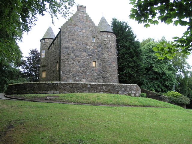
Image: © Richard Paxman Taken: 3 Jul 2006
In the Wallace Tower, Aberdeen has it’s very own castle, a fact unknown by most Aberdonians I suspect. Even less known is the fact that it didn’t always stand where it is now, beside the River Don in the less than totally salubrious surroundings of Tillydrone (my apologies to any offended Tillydronians!). It used to stand in the Nether Kirkgate, and was moved in 1964 to make way for the building of Marks & Spencer – at their expense! This photo shows it after it was moved, tomorrow's will show it before. It is more correctly called Benholm’s Tower, the reference to Wallace possibly being based on the figure of an unidentified knight in an exterior recess of one of the round towers, but more probably being a corruption of “well-house”, a reference to the well that formerly stood at the head of Carnegie’s Brae nearby. This small Z-plan castle was built as a townhouse by Sir Robert Keith of Benholm around 1600, and stood at that time in virtually open countryside, some 20 yards outside the medieval burgh boundary. Over the centuries, it passed through the hands of a succession of owners before becoming the property of the City of Aberdeen in 1918. The building looks better from a distance these days, because the original dressed stone around the doors and lintels were replaced with what looks like concrete when the building was moved.
Images are licensed for reuse under creativecommons.org/licenses/by-sa/2.0
Image Location


Leaflet Map data © OpenStreetMap
Latitude
57.170895
Longitude
-2.1083