Field beside Garshake Water Works
Introduction
The photograph on this page of Field beside Garshake Water Works by Lairich Rig as part of the Geograph project.
The Geograph project started in 2005 with the aim of publishing, organising and preserving representative images for every square kilometre of Great Britain, Ireland and the Isle of Man.

There are currently over 7.5m images from over 14,400 individuals and you can help contribute to the project by visiting https://www.geograph.org.uk
Field beside Garshake Water Works
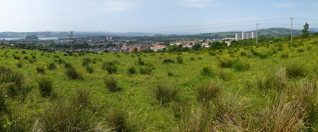
Image: © Lairich Rig Taken: 12 Jul 2013
This area is just to the north-west of Image The picture was taken from a Image Compare Image, taken from the same spot as the present photograph. On the left, Dumbarton Rock – http://www.geograph.org.uk/article/Dumbarton-Rock-and-Castle – can be seen on the near shore of the Clyde. On the right, Carman Hill (Image) and the muirs to its north are framed between two poles. Just to their left are the Image The nearer houses visible in the photograph are in Bellsmyre, while the more distant ones are in other parts of Dumbarton. The distant high flats, left of centre, are Image Behind the poles on the left is a large brick tower, the Image, best seen at larger image sizes.
Images are licensed for reuse under creativecommons.org/licenses/by-sa/2.0
Image Location
Latitude
55.956177
Longitude
-4.541116