The loss of the Iolaire
Introduction
The photograph on this page of The loss of the Iolaire by M J Richardson as part of the Geograph project.
The Geograph project started in 2005 with the aim of publishing, organising and preserving representative images for every square kilometre of Great Britain, Ireland and the Isle of Man.

There are currently over 7.5m images from over 14,400 individuals and you can help contribute to the project by visiting https://www.geograph.org.uk
The loss of the Iolaire
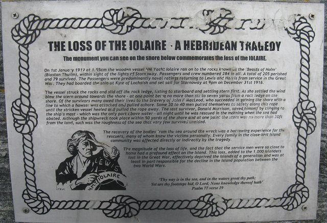
Image: © M J Richardson Taken: 12 May 2013
The memorial plaque with the story of A Hebridean Tragedy. 205 lives were lost when the ship hit the rocks on 1 January 1919. Most were naval ratings returning home after the Great War. The memorial is about 330m south east along a good path Image The plaque has weathered well in 8 years since Phil Smith's image Image The Commonwealth War Grave of R. Cook, an engineman on the Iolaire, is in Hull is shown at Image
Images are licensed for reuse under creativecommons.org/licenses/by-sa/2.0
Image Location
Latitude
58.192956
Longitude
-6.348478