All Saints church, Kemeys Commander
Introduction
The photograph on this page of All Saints church, Kemeys Commander by Jeremy Bolwell as part of the Geograph project.
The Geograph project started in 2005 with the aim of publishing, organising and preserving representative images for every square kilometre of Great Britain, Ireland and the Isle of Man.

There are currently over 7.5m images from over 14,400 individuals and you can help contribute to the project by visiting https://www.geograph.org.uk
All Saints church, Kemeys Commander
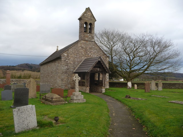
Image: © Jeremy Bolwell Taken: 9 Dec 2012
This small rural and isolated church was at one time, in the Middle Ages, held in the patronage of the Knights Templar and was a commandery or preceptory as their houses were termed. By the 17th century their successors, the Knights Hospitallers, drew £2 13s. 4d. per annum from demesne lands in this parish. The site may have been a religious one long before though. There may well have been a hermitage here in earlier days in the Norman period or even earlier. The slightly strange name of the settlement may not be associated with the local Kemeys family, early Norman invaders of Gwent and later Baronets at the time of the English Civil War. The Kemeys family are linked to Kemeys Inferior some nine miles (14 km) further down the River Usk in Wentwood. Furthermore, the Welsh language word 'cemais' meaning 'bend in a river' is apt as this describes the site of this village, which stands at the centre of a long bend of consistent radius in the adjacent River Usk / Afon Wysg. The church of All Saints is held with nearby Betws Newydd and has some interesting features such as 'a small low screen dividing the nave from the presbytery and taking the place of the usual chancel arch as the whole building is contained under one roof; the screen is plain and not of good workmanship, the only ornamentation being slight columns with crocketed pinnacles on each side of the entry. The altar slab, apparently not pre-Reformation, is severely mounted on plain stone squares and in keeping with the austere lines of the building. There are also a modern terfoiled aumbry and a piscina in the south wall. The east window is Perpendicular and high, and on the south side of the nave is an exceedingly small window which lighted the former rood-loft. The beams of the slightly flattened barrel roof and the wall-plate are of some age. The font is octagonal. The small south door has been built-in and entrance to the building is through the timbered west porch above which is a turret containing two bells, one of which is of 13th century date but slightly smaller than those at Gwernesney. Only the steps and base remain of the churchyard cross. In the middle of the 16th century the provision of a light in the church, probably that before the high altar, was charged upon three acres of land in the parish. The church house in the hamlet retains many features of the Renaissance period' ('Monmouthshire, Its History and Topography', C.J.O. Evans, 1950) Well worth a visit obviously.
Images are licensed for reuse under creativecommons.org/licenses/by-sa/2.0
Image Location
Latitude
51.738018
Longitude
-2.944315