Derelict jam factory, Cinder Lane, Louth: detail, 2012
Introduction
The photograph on this page of Derelict jam factory, Cinder Lane, Louth: detail, 2012 by Chris as part of the Geograph project.
The Geograph project started in 2005 with the aim of publishing, organising and preserving representative images for every square kilometre of Great Britain, Ireland and the Isle of Man.

There are currently over 7.5m images from over 14,400 individuals and you can help contribute to the project by visiting https://www.geograph.org.uk
Derelict jam factory, Cinder Lane, Louth: detail, 2012
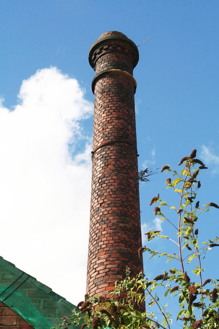
Image: © Chris Taken: 22 Sep 2012
As can be seen, the beautiful brickwork on the chimney is in good condition. To demolish it is a crying shame. The old jam factory, of which it is part, is still there despite the expectation in 2008 that it was soon to be replaced with housing (7 flats, and possibly a house too). See Image and Image As you can see, it is now home to quite an extensive collection of plants. One of the problems has been the chimney. Louth centre is a Conservation Area, and the chimney a respected feature of the Louth skyline. The developer was supposed to conserve it. However, after a further 4 years of being left untouched, the neighbours are now understandably fearful that debris will fall on their houses. So reluctantly East Lindsey District Council has had to give in to the developer's wish to demolish it.
Images are licensed for reuse under creativecommons.org/licenses/by-sa/2.0
Image Location


Leaflet Map data © OpenStreetMap
Latitude
53.364678
Longitude
-0.003016