The Watermill, Edenbridge High Street
Introduction
The photograph on this page of The Watermill, Edenbridge High Street by Stefan Czapski as part of the Geograph project.
The Geograph project started in 2005 with the aim of publishing, organising and preserving representative images for every square kilometre of Great Britain, Ireland and the Isle of Man.

There are currently over 7.5m images from over 14,400 individuals and you can help contribute to the project by visiting https://www.geograph.org.uk
The Watermill, Edenbridge High Street
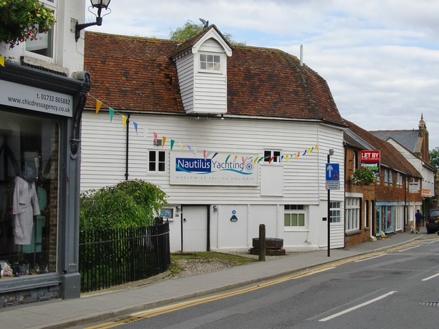
Image: © Stefan Czapski Taken: 15 Jul 2012
Along Edenbridge High Street there are many old buildings, from 15th century through to Georgian. This one catches the eye for three reasons: the extent of the weather-boarding, the hoist, and because it stands at an odd angle to the roadway. The angle plainly left room for a wagon to load or unload grain without obstructing the traffic. The proximity to water is not apparent from the High Street, and it was only when I googled 'Nautilus Yachting' that I discovered the building's original purpose. The building is 'listed', and the listing text runs as follows: 'No 87: C18 water mill with undershot wheel and stream running under road. Rounded tiled gambrel roof half-hipped at right. Weatherboarded with various casement windows and loading bay projecting on upper floor'.
Images are licensed for reuse under creativecommons.org/licenses/by-sa/2.0
Image Location
Latitude
51.195245
Longitude
0.065497