The State Hospital from the air
Introduction
The photograph on this page of The State Hospital from the air by Thomas Nugent as part of the Geograph project.
The Geograph project started in 2005 with the aim of publishing, organising and preserving representative images for every square kilometre of Great Britain, Ireland and the Isle of Man.

There are currently over 7.5m images from over 14,400 individuals and you can help contribute to the project by visiting https://www.geograph.org.uk
The State Hospital from the air
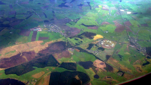
Image: © Thomas Nugent Taken: 14 May 2012
The State Hospital provides assessment, treatment and care in conditions of special security for individuals with mental disorder who, because of their dangerous, violent or criminal propensities, cannot be cared for in any other setting. This State Hospital is a Special Health Board as part of the NHS in Scotland. http://www.tsh.scot.nhs.uk/ The hospital is the small cluster of white buildings. Carstairs Junction is to the right, Carnwath to the left. The Scottish branches of the West Coast Main Line can be seen here. The line to the lower right leads to Glasgow Central, the line to the lower left leads to Edinburgh. The line of the former Dolphinton branch can be seen immediately above the hospital.
Images are licensed for reuse under creativecommons.org/licenses/by-sa/2.0
Image Location
Latitude
55.700869
Longitude
-3.648412