26 - 30 Broad Street
Introduction
The photograph on this page of 26 - 30 Broad Street by Ian Capper as part of the Geograph project.
The Geograph project started in 2005 with the aim of publishing, organising and preserving representative images for every square kilometre of Great Britain, Ireland and the Isle of Man.

There are currently over 7.5m images from over 14,400 individuals and you can help contribute to the project by visiting https://www.geograph.org.uk
26 - 30 Broad Street
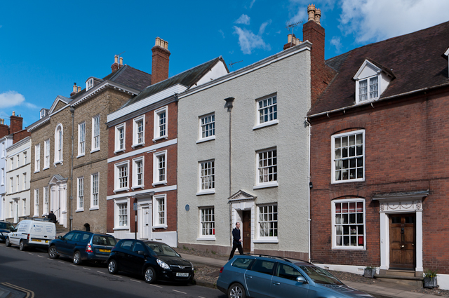
Image: © Ian Capper Taken: 10 Apr 2012
A row of houses in Broad Street, all listed. From right to left: No 30: Early 19th century, brick front, grade II listed - see www.historicengland.org.uk/listing/the-list/list-entry/1291541. No 29: 18th century, stucco front, grade II listed - see www.historicengland.org.uk/listing/the-list/list-entry/1219309. No 28: Late 18th century, brick front, grade II listed - see www.historicengland.org.uk/listing/the-list/list-entry/1281995. For closer view of Nos 28 and 29, see Image No 27: Mid 18th century, stone front, grade II* listed - see www.historicengland.org.uk/listing/the-list/list-entry/1291528. For closer view see Image No 26: Late 18th century, stucco front, grade II listed - see www.historicengland.org.uk/listing/the-list/list-entry/1202803.
Images are licensed for reuse under creativecommons.org/licenses/by-sa/2.0
Image Location
Latitude
52.365871
Longitude
-2.718156