Jordan Well
Introduction
The photograph on this page of Jordan Well by E Gammie as part of the Geograph project.
The Geograph project started in 2005 with the aim of publishing, organising and preserving representative images for every square kilometre of Great Britain, Ireland and the Isle of Man.

There are currently over 7.5m images from over 14,400 individuals and you can help contribute to the project by visiting https://www.geograph.org.uk
Jordan Well
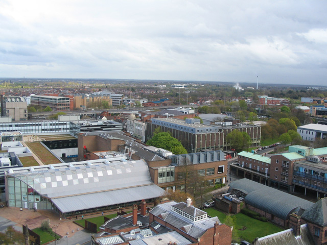
Image: © E Gammie Taken: 25 Apr 2012
Jordan Well crosses from lower right to upper left. In the immediate foreground is the roof of early 19th century Drapers Hall on the corner of Bayley Lane. To its right is a small green and the curved roof of Browns restaurant, which replaced the public toilets occupying what would have been the basement of the art gallery had its construction been completed on its intended site before WW2 intervened. Post-war the Herbert art gallery was constructed on the far side of Bayley Lane. On the far side of Jordan Well, on the right, are shops with flats above, constructed in the 1950s. To their left is Much Park Street and buildings of Coventry University. The Coventry University campus stretches beyond the ring road with the early 20th century William Morris building (a refurbished factory) and late 20th century Lanchester Library, amongst others. The chimney in the distance to the right is that of the Whitley waste reduction plant on London Road. How it looked in 1975: http://www.geograph.org.uk/photo/2917579 A circuit round the tower: http://www.geograph.org.uk/photo/2917558 < anti-clockwise | clockwise > http://www.geograph.org.uk/photo/2917634
Images are licensed for reuse under creativecommons.org/licenses/by-sa/2.0
Image Location
Latitude
52.406624
Longitude
-1.505899