Redevelopment work in Galashiels - Galashiels Health Centre
Introduction
The photograph on this page of Redevelopment work in Galashiels - Galashiels Health Centre by Walter Baxter as part of the Geograph project.
The Geograph project started in 2005 with the aim of publishing, organising and preserving representative images for every square kilometre of Great Britain, Ireland and the Isle of Man.

There are currently over 7.5m images from over 14,400 individuals and you can help contribute to the project by visiting https://www.geograph.org.uk
Redevelopment work in Galashiels - Galashiels Health Centre
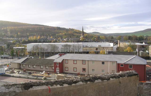
Image: © Walter Baxter Taken: 12 Nov 2006
Viewed from the top of the Station Brae, the health centre is the building in the foreground. The cream and burgundy coloured walls are extensions to the existing building, comprising two single storey extensions and one 2 storey extension. The existing internal layout was also completely revamped, and all while staff and patients had to use the building. This was only possible due to a series of complicated decant moves and the goodwill of the users. Access to the building has also been difficult due to major redevelopment works taking place around the health centre, including the construction of a new inner relief road, the demolition of a nearby bridge, and the erection of two large superstores. The white building behind the health centre is the new TESCO superstore that is due to open on 4th December 2006. The health centre will soon become fully operational, but some external works have also to be completed.
Images are licensed for reuse under creativecommons.org/licenses/by-sa/2.0
Image Location


Leaflet Map data © OpenStreetMap
Latitude
55.616126
Longitude
-2.803489