High Mains Quarry
Introduction
The photograph on this page of High Mains Quarry by Lairich Rig as part of the Geograph project.
The Geograph project started in 2005 with the aim of publishing, organising and preserving representative images for every square kilometre of Great Britain, Ireland and the Isle of Man.

There are currently over 7.5m images from over 14,400 individuals and you can help contribute to the project by visiting https://www.geograph.org.uk
High Mains Quarry
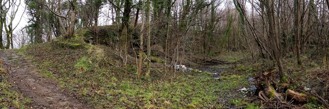
Image: © Lairich Rig Taken: 23 Dec 2011
OS maps indicate that the quarry had fallen into disuse by the mid-1960s. The path shown in this photograph follows the original course of Barnhill Road. That former road is now no more than a track, but it is still in use as part of a local route, Overtoun House Circular Path. The present-day Barnhill Road follows a rather different course: Image The former quarry is about 400 metres long (E-W), by about 20 metres wide (N-S), and is in two halves, one higher than the other; the halves are separated by the section of path shown here. To the left of the path, there is a sheer drop (behind a fence) to the lower western part, the older half of the quarry (intervening trees make it hard to show that area photographically). To the right of the path, as shown in the present photograph, is the entrance to the higher and more recent eastern half of the quarry; this part was largely excavated after 1938. For a view from the opposite end of this half of the quarry, see Image The back part of the quarry (as it appears in the present picture) has a raised edge, as shown in views from the woods there: Image / Image There was a quarry at High Mains at the time of the first-edition OS map (c.1860), but it was then much smaller, and did not extend very far from the vicinity of Image (High Mains Quarry began there, and, over the years, was gradually extended further to the east).
Images are licensed for reuse under creativecommons.org/licenses/by-sa/2.0
Image Location
Latitude
55.944491
Longitude
-4.536827