East Port, Cowgate
Introduction
The photograph on this page of East Port, Cowgate by kim traynor as part of the Geograph project.
The Geograph project started in 2005 with the aim of publishing, organising and preserving representative images for every square kilometre of Great Britain, Ireland and the Isle of Man.

There are currently over 7.5m images from over 14,400 individuals and you can help contribute to the project by visiting https://www.geograph.org.uk
East Port, Cowgate
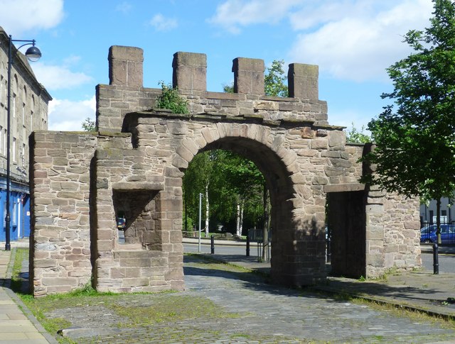
Image: © kim traynor Taken: 22 May 2011
The view from the town side. The official listed buildings record contains the following note: "The only remainder of Dundee's town walls and one of only 2 burgh gateways in Scotland. Dundee did not have a continuous walled rampart, but relied for a boundary on back dykes of houses. The Cowgait Port was more a customs post for the collection of revenue than a serious piece of fortification. After the last siege of a town in Britain and Dundee's brutal sacking in 1651, General Monck ordered the slighting and demolition of the towns defensive works. The Cowgait Port was spared, presumably because of its association with the protestant reformer and martyr George Wishart. According to Knox he preached to plague victims in 1544 from "the East Port", which could refer to the larger port on the Seagate or the lesser one in the Cowgate. The latter, adjacent to the old St Roques Chapel, burying ground for plague victims and site for the Old Wishart Church, seems more likely. It has been argued that Dundee's fortifications were extended in 1650 in anticipation of attack by Cromwell and that the Cowgate Port was then moved to its present position. But a stone gateway would have been no use in an artillery siege, so in all probability this is the site from which Wishart preached."
Images are licensed for reuse under creativecommons.org/licenses/by-sa/2.0
Image Location
Latitude
56.464868
Longitude
-2.964148