Icosahedral Sundial, Marsden Park, Nelson, Lancashire
Introduction
The photograph on this page of Icosahedral Sundial, Marsden Park, Nelson, Lancashire by Robert Wade as part of the Geograph project.
The Geograph project started in 2005 with the aim of publishing, organising and preserving representative images for every square kilometre of Great Britain, Ireland and the Isle of Man.

There are currently over 7.5m images from over 14,400 individuals and you can help contribute to the project by visiting https://www.geograph.org.uk
Icosahedral Sundial, Marsden Park, Nelson, Lancashire
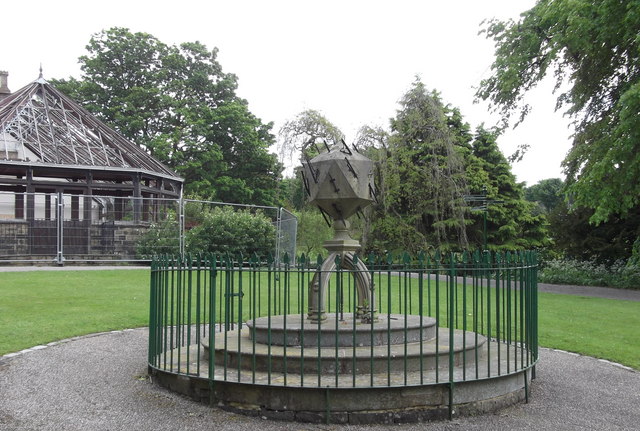
Image: © Robert Wade Taken: 19 May 2011
Icosahedral, or twenty-sided sundial that tells the time in various places all around the world that were influential when it was designed in the 1840s. The many gnomons tell the time in places such as Washington, Moscow, Rome, Jerusalem, Calcutta, St Helena and the Cape of Good Hope. The sundial was designed by Thornber and Kippax, and according to an inscription on one of the faces was first installed on June 15th 1841. Originally positioned to the south-east of the Roman Baths it was moved to its present location in the 1930s. It was commissioned by R.T. Walton who was a 19th century descendant of the de Walton family. Edward III gave the land here to Richard de Walton in the 14th century and the family remained here until 1911, when they ran out of male heirs and the property was purchased by the local authority. It was restored in 1986 and placed behind railings to keep it safe from vandalism. An inscription on the base reads: "This plaque is a mark of appreciation for the efforts of Roger Macaulay Lord who restored this sun dial in 1986. His hard work skill and dedication were given freely to ensure that the sun dial continues to be an object of interest to visitors to Marsden Park for years to come" Many thanks to Lancashire Sundials
Images are licensed for reuse under creativecommons.org/licenses/by-sa/2.0
Image Location
Latitude
53.839094
Longitude
-2.186882