Railway bridge abutments at Trent Lane
Introduction
The photograph on this page of Railway bridge abutments at Trent Lane by John Sutton as part of the Geograph project.
The Geograph project started in 2005 with the aim of publishing, organising and preserving representative images for every square kilometre of Great Britain, Ireland and the Isle of Man.

There are currently over 7.5m images from over 14,400 individuals and you can help contribute to the project by visiting https://www.geograph.org.uk
Railway bridge abutments at Trent Lane
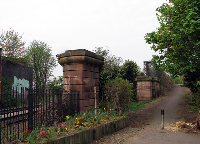
Image: © John Sutton Taken: 15 Apr 2011
In the heyday of Nottingham’s railways the railway infrastructure at Trent Lane was complex. The Midland Railway Nottingham-Newark-Lincoln line, still in use, is at the lowest level. From 1857 trains from the Great Northern Railway’s London Road station (and, from 1900, Nottingham Victoria) to Grantham, Derby Friargate via the Back Line through Gedling and Basford, and Northampton via the GN&LNWJt line through Melton Mowbray passed above Trent Lane level crossing on a plate girder bridge supported by the stone abutments shown here. The last addition, in 1889, was the Nottingham Suburban Railway, which left the GNR at Trent Lane Junction. Southbound Suburban Railway trains from Daybrook crossed the Lincoln and Grantham lines on girder bridges east of Trent Lane before dropping down to cross it on an arched blue-brick bridge, the most substantial surviving relic of the NSR, which lost its passenger service in 1916. The NSR then re-crossed the Lincoln line on a truss girder bridge before continuing to London Road; the blue-brick abutment on the left supported this bridge. The NSR continued to serve brickworks at Mapperley and Thorneywood until 1951; those trains used the northern junction at Daybrook as this southern section had been abandoned after being damaged by bombing in 1941. Since Nottingham Victoria closed in the 1960s Grantham trains have used the Midland route as far as Netherfield. In Sneinton little remains of the Great Northern apart from London Road Station (now a health club) and the derelict goods warehouses near it, the remains of the bridges at Meadow Lane and the bridge and abutments here. The path on the right follows the former track as far as Manvers Street. Trent Lane Junction Signal Box was at the higher level behind the tree on the right. See Image], Image], Image], Image], Image], Image] and others.
Images are licensed for reuse under creativecommons.org/licenses/by-sa/2.0
Image Location
Latitude
52.948212
Longitude
-1.123812