Houldsworth Mill
Introduction
The photograph on this page of Houldsworth Mill by David Dixon as part of the Geograph project.
The Geograph project started in 2005 with the aim of publishing, organising and preserving representative images for every square kilometre of Great Britain, Ireland and the Isle of Man.

There are currently over 7.5m images from over 14,400 individuals and you can help contribute to the project by visiting https://www.geograph.org.uk
Houldsworth Mill
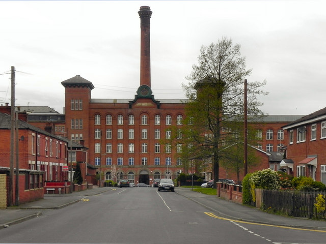
Image: © David Dixon Taken: 13 Apr 2011
Looking along Rupert Street, towards Houldsworth Mill. Houldsworth Mill, also known as Reddish Mill, is a former mill built in 1865 at the height of the cotton production boom in the north-west of England. It was constructed for Henry Houldsworth, a prominent mill owner at the time. As well as a mill, Reddish boasts a road, a large pub and the main town square all named in his honour. Cotton production at Houldsworth Mill ceased in the 1950s. The mill was sold to the John Myers mail-order catalogue company and was used principally as a warehouse. Mail-order trading ceased in the 1970s, and the mill was divided into separate business units, but most of the building remained vacant and it fell into a state of disrepair. Since 1998, Houldsworth Mill has undergone substantial renovation and restoration financed by local business organisations, the local town council and by grants from English Heritage3, and similar organisations, such as the Prince's Trust. The extension to the rear of the mill accommodates several businesses, and the second floor contains a Craft Village. The north end of the mill comprises a modern business centre and a large conference centre. The mill is currently a Grade II* listed building. http://en.wikipedia.org/wiki/Houldsworth_Mill,_Reddish – Wikipedia article about Houldsworth Mill http://www.bbc.co.uk/dna/h2g2/A564699 - BBC h2g2 guide http://www.imagesofengland.org.uk/details/default.aspx?id=210821 – Images of England National Monuments Record
Images are licensed for reuse under creativecommons.org/licenses/by-sa/2.0
Image Location
Latitude
53.436301
Longitude
-2.165539