Seismoscope, Earthquake House Comrie
Introduction
The photograph on this page of Seismoscope, Earthquake House Comrie by Jim Barton as part of the Geograph project.
The Geograph project started in 2005 with the aim of publishing, organising and preserving representative images for every square kilometre of Great Britain, Ireland and the Isle of Man.

There are currently over 7.5m images from over 14,400 individuals and you can help contribute to the project by visiting https://www.geograph.org.uk
Seismoscope, Earthquake House Comrie
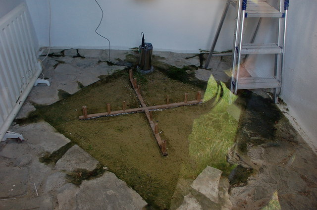
Image: © Jim Barton Taken: 7 Oct 2010
This is a reconstruction of the early instrument for monitoring earthquake tremors installed in this purpose-built shelter in 1874. The wooden cross lies on a bed of sand to isolate it from nearby disturbance. On each arm are placed three wooden cylinders of the same height but different diameters. A tremor would cause one or more cylinders to topple, with only a strong tremor affecting the thickest cylinders. Hence the number and direction of cylinders knocked down and recorded in the sand would indicate strength and direction of a tremor. In fact, the earthquake activity of the 1840's did not recur, and the instrument never functioned. The building was restored from 1986 by Perth and Kinross Council with Perth and Kinross Heritage Trust and British Geological Survey. BGS maintain a modern seismometer, here visible as the metal cylinder at the top corner of the sand tray. The green colouration is due to reflection in the glass window through which the photograph was taken.
Images are licensed for reuse under creativecommons.org/licenses/by-sa/2.0
Image Location
Latitude
56.371786
Longitude
-4.000957