Auchincarroch Road
Introduction
The photograph on this page of Auchincarroch Road by Lairich Rig as part of the Geograph project.
The Geograph project started in 2005 with the aim of publishing, organising and preserving representative images for every square kilometre of Great Britain, Ireland and the Isle of Man.

There are currently over 7.5m images from over 14,400 individuals and you can help contribute to the project by visiting https://www.geograph.org.uk
Auchincarroch Road
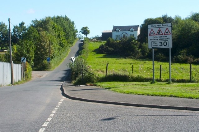
Image: © Lairich Rig Taken: 27 Aug 2010
The photograph was taken at the junction with Napierston Road, which leads into Dalmonach on the right. The "Core Path Route" sign was, at this time, a fairly recent addition. The entrance of a Image can be seen on the left; compare Image, taken from about 250 metres further back. The name Auchincarroch, associated with this area, is an old one; the present-day spelling of the name is not entirely consistent: some of the farms located along the road use the spelling "Auchencarroch", while the road itself and the nearby hill have "Auchincarroch". An old form of the name appears in a charter granted in 1270 by Maldowen, Earl of Lennox; it mentions "the land of Hachenkeroch, in the parish of Buthelulle". The latter name, that of the parish, developed into the present-day form "Bonhill"; see Image [For the "Auch-" names in this district, see the chapter by Simon Taylor in the book "Changing Identities, Ancient Roots" (2006). There, the author cites another early form, "Hachenkerach" (c.1247). On the name Dalmonach, encountered above, see Image] The building up on the hill is Woodside, the farmhouse of Woodside Farm. Immediately behind it, though not visible from this angle, are some farm buildings, which, despite a "Napierston Farm" sign on them, are those of Woodside Farm. The buildings of the actual Napierston Farm (which was in the possession of the same family) were demolished less than a decade before this photograph was taken; their former site is just out of shot to the right, immediately next to the grassy area in the right foreground. For more on that subject, see Image and Image, where that area is visible.
Images are licensed for reuse under creativecommons.org/licenses/by-sa/2.0
Image Location
Latitude
55.993557
Longitude
-4.567625