Up Yewberry Lane,Malpas
Introduction
The photograph on this page of Up Yewberry Lane,Malpas by Jaggery as part of the Geograph project.
The Geograph project started in 2005 with the aim of publishing, organising and preserving representative images for every square kilometre of Great Britain, Ireland and the Isle of Man.

There are currently over 7.5m images from over 14,400 individuals and you can help contribute to the project by visiting https://www.geograph.org.uk
Up Yewberry Lane,Malpas
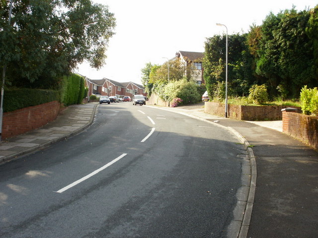
Image: © Jaggery Taken: 13 Aug 2009
The walker or cyclist wishing to travel from the Pillmawr Road area of Malpas to Newport City Centre, a journey of about 2 miles, has 3 main choices. One is via Malpas Road. This route is flat at the start and end, with a descent http://www.geograph.org.uk/photo/1460900 towards the M4 motorway in the middle part. It has the disadvantage of being alongside a busy A road. The second route is via the cycle path http://www.geograph.org.uk/photo/1436206. This route is mostly flat. The middle part is semirural, and adjacent to the river Usk. But it is the longest of the three routes for those departing from the middle part of Pillmawr Road. The shortest route is via the shortcut to Brynglas http://www.geograph.org.uk/photo/1429388. However, this route is the steepest, with a long steep climb towards Brynglas up Yewberry Lane. The steepness of the route is shown here, viewed from the junction with Pillmawr Road. Yewberry Lane climbs 30 metres (about 100 feet) to one of the highest points in Newport. First-time walkers up Yewberry Lane may find that they end up with aching leg muscles, whereas seasoned walkers take it in their stride.
Images are licensed for reuse under creativecommons.org/licenses/by-sa/2.0
Image Location
Latitude
51.609074
Longitude
-2.999257