Marsh Lane Narrows, near Wolverhampton
Introduction
The photograph on this page of Marsh Lane Narrows, near Wolverhampton by Roger D Kidd as part of the Geograph project.
The Geograph project started in 2005 with the aim of publishing, organising and preserving representative images for every square kilometre of Great Britain, Ireland and the Isle of Man.

There are currently over 7.5m images from over 14,400 individuals and you can help contribute to the project by visiting https://www.geograph.org.uk
Marsh Lane Narrows, near Wolverhampton
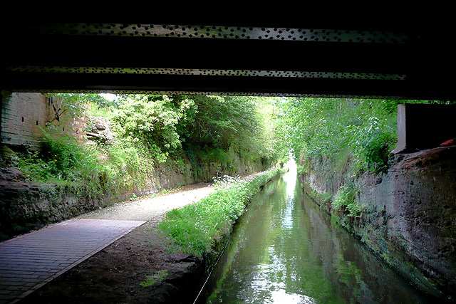
Image: © Roger D Kidd Taken: 26 May 2009
The Staffordshire and Worcestershire Canal, cut directly into the sandstone bedrock, is less than the width of two boats. This is the narrowest part of the canal, about nine feet, seen from under Forster Bridge No 68. About two hundred metres forward the canal widens out again, but by the time a narrowboat travelling north reaches this bridge it can be seen so boats will wait. Sequence: a passage north through the narrows, last image #8. The first image is Image]
Images are licensed for reuse under creativecommons.org/licenses/by-sa/2.0
Image Location
Latitude
52.630616
Longitude
-2.136474