Entrance to The Barons' Cave
Introduction
The photograph on this page of Entrance to The Barons' Cave by Ian Capper as part of the Geograph project.
The Geograph project started in 2005 with the aim of publishing, organising and preserving representative images for every square kilometre of Great Britain, Ireland and the Isle of Man.

There are currently over 7.5m images from over 14,400 individuals and you can help contribute to the project by visiting https://www.geograph.org.uk
Entrance to The Barons' Cave
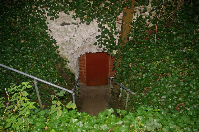
Image: © Ian Capper Taken: 14 Sep 2008
Lower entrance to the cave, which is the access point on the four or so days a year when it is open to the public. The cave is under the site of the former Reigate Castle, and there are a number of theories about its purpose, ranging from simply being the castle cellars through to being an escape route or a refuge. The reason for the name is that for many years the story was that this was the meeting point of the barons prior to meeting King John at Runnymede for the sealing of the Magna Carta, although this story has now been discredited. However, it added a bit of interest to the place, and perhaps explains why it has been a visitor's attraction, on and off, for many years, with references back to the 17th century and regular visits likely to have been made from the second half of the 18th century. For further information see http://www.wcms.org.uk/pages/club/barons_cave.shtml with further information available in the booklet "The Barons' Cave" by Peter Burgess, published by the Wealden Cave and Mine Society. Information and photos also at http://www.subbrit.org.uk/sb-sites/sites/b/barons/index.shtml. The stone surround to the entrance, in Reigate stone, probably dates from the mid nineteenth century when this entrance was restored, having previously been blocked for many years - prior to this the main access would have been the upper entrance - see Image The iron pipe to the right of the door was installed in the 1940s to improve ventilation to the old sand mines which extended from below the cave through to under London Road, which were filled in in the 1980s due to concern of the risk of collapse.
Images are licensed for reuse under creativecommons.org/licenses/by-sa/2.0
Image Location
Latitude
51.238492
Longitude
-0.208974