Overview for Lease Rigg, WHITBY, YO22 5BE
Introduction
Whitby is a seaside town, port and civil parish in North Yorkshire, England. The town is on the Yorkshire Coast at the mouth of the River Esk. It has a maritime, mineral and tourist economy. The fishing port emerged during the Middle Ages, supporting important herring and whaling fleets, and was where Captain Cook learned seamanship and, coincidentally, where his first vessel to explore the southern ocean, HMS Endeavour was built. Jet and alum were mined locally, and Whitby jet, which was mined by the Romans and Victorians, became fashionable during the 19th century.
The earliest record of a permanent settlement is in 656 AD, when as Streanæshealh it was the place where Oswy, the Christian king of Northumbria, founded the first abbey, under the abbess Hilda. The Synod of Whitby was held there in 664 AD. In 867 AD, Viking raiders destroyed the monastery. The town's East Cliff is home to the ruins of Whitby Abbey, where Cædmon, the earliest recognised English poet, lived. Another monastery was founded in 1078 AD. It was in this period that the town gained its current name, Whitby (from "white settlement" in Old Norse). In the following centuries Whitby functioned as a fishing settlement until, in the 18th century, it developed as a port and centre for shipbuilding and whaling, the trade in locally mined alum, and the manufacture of Whitby jet jewellery. Tourism started in Whitby during the Georgian period and developed with the arrival of the railway in 1839.
Its attraction as a tourist destination is enhanced by the proximity of the high ground of the North York Moors national park and the heritage coastline and by association with the horror novel Dracula. The abbey ruin at the top of the East Cliff is the town's oldest and most prominent landmark. Other significant features include the swing bridge, which crosses the River Esk and the harbour, which is sheltered by the grade II listed East and West piers. The town's maritime heritage is commemorated by statues of the explorer Captain Cook and the whaler and scientist William Scoresby, as well as the whalebone arch that sits at the top of the West Cliff. The town also has a strong literary tradition and has featured in literary works, television and cinema, most famously in Bram Stoker's novel Dracula.
While Whitby's cultural and historical heritage contribute to the local economy, the town does suffer from the economic constraints of its remote location, ongoing changes in the fishing industry, relatively underdeveloped transport infrastructure, and limitations on available land and property. As a result, tourism and some forms of fishing remain the mainstay of its economy. It is the closest port to a proposed wind farm development in the North Sea, 47 miles (76 km) from York and 22 miles (35 km) from Middlesbrough. There are transport links to the rest of North Yorkshire and North East England, primarily through national rail links to Middlesbrough and road links to Teesside, via both the A171 and A174, and Scarborough by the former. As at 2011, the town had a population of 13,213.
Summary for Lease Rigg, WHITBY, YO22 5BE
Roadworks near YO22 5BE
Road Safety near YO22 5BE
Details of personal injury accidents in and around Lease Rigg, YO22 5BE that have been reported to North Yorkshire Police over the past 20 years.
Traffic Levels near YO22 5BE
View traffic levels near Lease Rigg, YO22 5BE from official Department for Transport counts.
Images taken near to Lease Rigg, YO22 5BE and the surrounding area
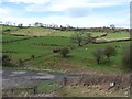
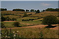
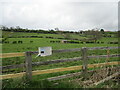

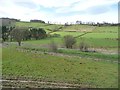
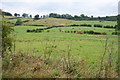
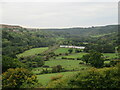
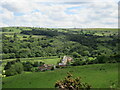
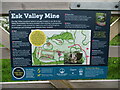
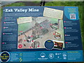
Please click the More button for more images, licensing and image copyright information.
Member of UK Parliament
This postcode is in the Scarborough and Whitby parliamentary constituency.
Scarborough and Whitby is a constituency in the Yorkshire and The Humber region of England. The seat has been held by Sir Robert Goodwill (Conservative) since May 2010.

Most Recent House Sales for Lease Rigg, YO22 5BE
3 Aug 2009
5 Jun 1998
Local Petrol Station Prices
Coordinates for YO22 5BE
Residents at YO22 5BE
Sunrise and Sunset at YO22 5BE
Traffic Emission and Congestion Zones
Historical Weather Summary
| Clear | 9.19% |
| Cloudy | 42.92% |
| Rain | 8.39% |
| Windy | 38.22% |
| Other | 1.28% |
Deprivation Index
the more deprived the postcode
Average Energy Performance
Companies Registered at YO22 5BE
National Park for YO22 5BE
Postcode Details for YO22 5BE
Recent Updates
|
18 Apr 2024 Added Traffic Camera Views from Traffic Scotland to Roadworks within Scotland |
|
15 Apr 2024 Schools Data updated for April 2024 |
|
10 Apr 2024 Companies Data updated for March 2024 |
|
7 Apr 2024 New option to receive automatic updates to roadworks that affect you |
|
7 Apr 2024 Police and Crime data updated for February 2024 |
|
3 Apr 2024 Sold House Price data updated for February 2024 |
|
30 Mar 2024 Energy Performance Certificates (England and Wales) updated February 2024 |
|
28 Mar 2024 New feature to use Geolocating functions to detect your current location |
Random Postcodes
Want an idea of what is in our extensive website? Try somewhere completely random!
The Rural/Urban classification is based upon data collected during the 2011 Census and released in August 2013 and is categorised into 6 distinct classes.
[A] Urban Major conurbation: A built up area with a population of 10,000 (3,000 in Scotland) or more and is assigned to the major conurbation settlement category.
[B] Urban Minor conurbation: A built up area with a population of 10,000 (3,000 in Scotland) or more and is assigned to the minor conurbation settlement category.
[C] Urban City and town: A built up area with a population of 10,000 (3,000 in Scotland) or more and is assigned to the city and town settlement category.
[D] Rural Town and fringe
[E] Rural Village
[F] Rural Hamlet and isolated dwelling
The Index of Multiple Deprivation (IMD) is the official measure of relative deprivation.
The index is based on 39 separate indicators across seven distinct domains (Income; Employment; Health and Disability; Education, Skills and Training; Crime; Barriers to Housing and Services; Living Environment) to provide an overall measure of multiple deprivation and is calculated for every neighbourhood.
The index is relative rather than an absolute scale and so a neighbourhood with a score of 10 is more deprived than one rated 20, but this does not equate to being twice as deprived.
Please note: Different indices are used in England, Scotland, Wales and Northern Ireland and so comparison of scores from neighbourhoods in different countries should not be undertaken.
These figures report on incorporated UK companies only that are registered at this postcode and do not include sole-traders, partnerships or overseas organisations.
The population figure shown for your area are an estimate provided by the Office for National Statistics and is rounded to the nearest 1,000.
The estimates are derived from the Annual Population Survey (APS) which is the Labour Force Survey (LFS) plus various sample boosts.
There are 55 unitary authorities. They provide all local government services in their areas. These are mainly in the cities, urban areas and larger towns although there are now 6 shire county councils that are unitary (ie have no district councils beneath them).