Overview for Church Street, TY CROES, LL63 5LQ
Introduction
Tŷ Croes is a small settlement two miles east of Rhosneigr, Anglesey, Wales.
It was, for a short time, the home of No. 144 Signals Unit RAF, an RAF Strike Command mobile radar reserve.
It has a railway station on the North Wales Coast Line which runs between Holyhead and Crewe.
Tŷ Croes is home to Anglesey Circuit that holds events at both club and national level. The circuit was extended in 2006 and is used by a number of groups for testing both cars and motorcycles. One advantage of the circuit is its comparative remoteness (from London) which allows testing to be done without attracting too much attention.
Summary for Church Street, TY CROES, LL63 5LQ
Roadworks near LL63 5LQ
A local roadworks feed is not available for Wales at this time.
However, Traffic Wales/Traffig Cymru provide works details for motorways and major trunk roads in Wales on their website at traffic.wales/roadworks
Road Safety near LL63 5LQ
Details of personal injury accidents in and around Church Street, LL63 5LQ that have been reported to North Wales Police over the past 20 years.
Traffic Levels near LL63 5LQ
View traffic levels near Church Street, LL63 5LQ from official Department for Transport counts.
Images taken near to Church Street, LL63 5LQ and the surrounding area
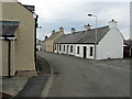
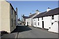
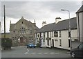
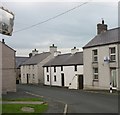
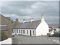
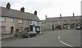
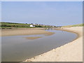
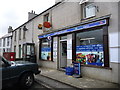
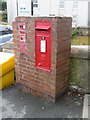
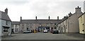
Please click the More button for more images, licensing and image copyright information.
Member of UK Parliament
This postcode is in the Ynys Môn parliamentary constituency.
Ynys Môn is a constituency in Wales. The seat has been held by Virginia Crosbie (Conservative) since December 2019.

Most Recent House Sales for Church Street, LL63 5LQ
26 Oct 2023
25 Jul 2022
22 Dec 2020
6 Mar 2019
Local Petrol Station Prices
Coordinates for LL63 5LQ
Residents at LL63 5LQ
Sunrise and Sunset at LL63 5LQ
Traffic Emission and Congestion Zones
Historical Weather Summary
| Clear | 15.79% |
| Cloudy | 64.18% |
| Rain | 10.00% |
| Windy | 9.87% |
| Other | 0.16% |
Population
Deprivation Index
the more deprived the postcode
Average Energy Performance
Companies Registered at LL63 5LQ
Postcode Details for LL63 5LQ
Recent Updates
|
18 Apr 2024 Added Traffic Camera Views from Traffic Scotland to Roadworks within Scotland |
|
15 Apr 2024 Schools Data updated for April 2024 |
|
10 Apr 2024 Companies Data updated for March 2024 |
|
7 Apr 2024 New option to receive automatic updates to roadworks that affect you |
|
7 Apr 2024 Police and Crime data updated for February 2024 |
|
3 Apr 2024 Sold House Price data updated for February 2024 |
|
30 Mar 2024 Energy Performance Certificates (England and Wales) updated February 2024 |
|
28 Mar 2024 New feature to use Geolocating functions to detect your current location |
Random Postcodes
Want an idea of what is in our extensive website? Try somewhere completely random!
The Rural/Urban classification is based upon data collected during the 2011 Census and released in August 2013 and is categorised into 6 distinct classes.
[A] Urban Major conurbation: A built up area with a population of 10,000 (3,000 in Scotland) or more and is assigned to the major conurbation settlement category.
[B] Urban Minor conurbation: A built up area with a population of 10,000 (3,000 in Scotland) or more and is assigned to the minor conurbation settlement category.
[C] Urban City and town: A built up area with a population of 10,000 (3,000 in Scotland) or more and is assigned to the city and town settlement category.
[D] Rural Town and fringe
[E] Rural Village
[F] Rural Hamlet and isolated dwelling
The Index of Multiple Deprivation (IMD) is the official measure of relative deprivation.
The index is based on 39 separate indicators across seven distinct domains (Income; Employment; Health and Disability; Education, Skills and Training; Crime; Barriers to Housing and Services; Living Environment) to provide an overall measure of multiple deprivation and is calculated for every neighbourhood.
The index is relative rather than an absolute scale and so a neighbourhood with a score of 10 is more deprived than one rated 20, but this does not equate to being twice as deprived.
Please note: Different indices are used in England, Scotland, Wales and Northern Ireland and so comparison of scores from neighbourhoods in different countries should not be undertaken.
These figures report on incorporated UK companies only that are registered at this postcode and do not include sole-traders, partnerships or overseas organisations.
The population figure shown for your area are an estimate provided by the Office for National Statistics and is rounded to the nearest 1,000.
The estimates are derived from the Annual Population Survey (APS) which is the Labour Force Survey (LFS) plus various sample boosts.
There are 55 unitary authorities. They provide all local government services in their areas. These are mainly in the cities, urban areas and larger towns although there are now 6 shire county councils that are unitary (ie have no district councils beneath them).