Overview for Achmore, STROME FERRY, IV53 8UT
Introduction
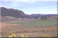
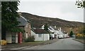
Stromeferry is a village, located on the south shore of the west coast sea loch, Loch Carron, in western Ross-shire, Scottish Highlands and is in the Scottish council area of Highland. Its name reflects its former role as the location of one of the many coastal ferry services which existed prior to the expansion of the road network in the 20th century.
It is served by Stromeferry railway station and is close to the A890 road. Stromeferry is on the southern bank of Loch Carron; Strome Castle is opposite on the northern bank.
The village is referred to in Iain Banks's novel Complicity, where the narrator describes the road sign marking the village, which states "Strome Ferry (No ferry)".
Some local shinty players once competed as "Stromeferry (No Ferry) United".
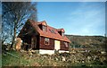
The village has been subject of various development proposals focussing on the derelict hotel. In November 2007, W.
A. Fairhurst & Partners, on behalf of the Helmsley Group, secured an outline planning consent for reinstating the hotel and building a number of new homes.
formerly the community had two church congregations, the Free Church of Scotland and the Church of Scotland. Both have subsequently united with other congregations, and the buildings transferred to private usage. The Church of Scotland building was closed in 1989.
Summary for Achmore, STROME FERRY, IV53 8UT
Roadworks near IV53 8UT
Road Safety near IV53 8UT
Details of personal injury accidents in and around IV53 8UT that have been reported to over the past 20 years.
Traffic Levels near IV53 8UT
View traffic levels near IV53 8UT from official Department for Transport counts.
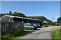
Images taken in and around the iv538ut area
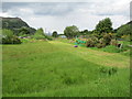
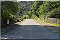
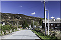
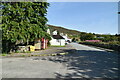
Please click the More button for more images, licensing and image copyright information.
Member of UK Parliament
This postcode is in the Ross, Skye and Lochaber parliamentary constituency.
Ross, Skye and Lochaber is a constituency in Scotland. The seat has been held by Ian Blackford (Scottish National Party) since May 2015.

Most Recent House Sales for IV53 8UT
No recorded house sales or transfers for this postcode.
Local Petrol Station Prices
Coordinates for IV53 8UT
Sunrise and Sunset at IV53 8UT
Traffic Emission and Congestion Zones
Historical Weather Summary
| Clear | 5.71% |
| Cloudy | 61.14% |
| Rain | 17.89% |
| Windy | 14.33% |
| Other | 0.93% |
Average Energy Performance
Companies Registered at IV53 8UT
Postcode Details for IV53 8UT
Recent Updates
|
18 Apr 2024 Added Traffic Camera Views from Traffic Scotland to Roadworks within Scotland |
|
15 Apr 2024 Schools Data updated for April 2024 |
|
10 Apr 2024 Companies Data updated for March 2024 |
|
7 Apr 2024 New option to receive automatic updates to roadworks that affect you |
|
7 Apr 2024 Police and Crime data updated for February 2024 |
|
3 Apr 2024 Sold House Price data updated for February 2024 |
|
30 Mar 2024 Energy Performance Certificates (England and Wales) updated February 2024 |
|
28 Mar 2024 New feature to use Geolocating functions to detect your current location |
Random Postcodes
Want an idea of what is in our extensive website? Try somewhere completely random!
The Rural/Urban classification is based upon data collected during the 2011 Census and released in August 2013 and is categorised into 6 distinct classes.
[A] Urban Major conurbation: A built up area with a population of 10,000 (3,000 in Scotland) or more and is assigned to the major conurbation settlement category.
[B] Urban Minor conurbation: A built up area with a population of 10,000 (3,000 in Scotland) or more and is assigned to the minor conurbation settlement category.
[C] Urban City and town: A built up area with a population of 10,000 (3,000 in Scotland) or more and is assigned to the city and town settlement category.
[D] Rural Town and fringe
[E] Rural Village
[F] Rural Hamlet and isolated dwelling
The Index of Multiple Deprivation (IMD) is the official measure of relative deprivation.
The index is based on 39 separate indicators across seven distinct domains (Income; Employment; Health and Disability; Education, Skills and Training; Crime; Barriers to Housing and Services; Living Environment) to provide an overall measure of multiple deprivation and is calculated for every neighbourhood.
The index is relative rather than an absolute scale and so a neighbourhood with a score of 10 is more deprived than one rated 20, but this does not equate to being twice as deprived.
Please note: Different indices are used in England, Scotland, Wales and Northern Ireland and so comparison of scores from neighbourhoods in different countries should not be undertaken.
These figures report on incorporated UK companies only that are registered at this postcode and do not include sole-traders, partnerships or overseas organisations.
The population figure shown for your area are an estimate provided by the Office for National Statistics and is rounded to the nearest 1,000.
The estimates are derived from the Annual Population Survey (APS) which is the Labour Force Survey (LFS) plus various sample boosts.
There are 55 unitary authorities. They provide all local government services in their areas. These are mainly in the cities, urban areas and larger towns although there are now 6 shire county councils that are unitary (ie have no district councils beneath them).