Overview for Main Street, GULLANE, EH31 2AR
Introduction
Gullane (GUL-ən or GIL-ən) is a town on the southern shore of the Firth of Forth in East Lothian on the east coast of Scotland. There has been a church in the village since the ninth century. The ruins of the Old Church of St. Andrew built in the twelfth century can still be seen at the western entrance to the village; the church was abandoned after a series of sandstorms made it unusable, and Dirleton Parish Church took its place.
Gullane Bents, the village's award-winning beach, is backed by large sand dunes that in recent years have become rather overgrown by invasive shrubs like sea-buckthorn. Gullane is part of the John Muir Way, a long-distance footpath along the coast between Musselburgh and Dunglass.
The local population includes a higher than average percentage of elderly people, but also attracts young families and commuters for Edinburgh. Urbanisation has led to some recent housing developments being approved on greenbelt land around the village, and Gullane is gaining popularity as a commuter village for nearby Edinburgh (22 miles (35 km) away), despite the poor transport to the village. Amenities include the village hall and a variety of shops. There is a primary school, and local children attend secondary school (5 miles (8 km)) away in North Berwick.
Summary for Main Street, GULLANE, EH31 2AR
Roadworks near EH31 2AR
Road Safety near EH31 2AR
Details of personal injury accidents in and around Main Street, EH31 2AR that have been reported to over the past 20 years.
Traffic Levels near EH31 2AR
View traffic levels near Main Street, EH31 2AR from official Department for Transport counts.
Images taken near to Main Street, EH31 2AR and the surrounding area
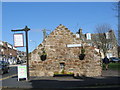
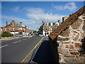

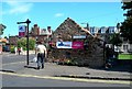
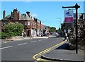
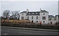

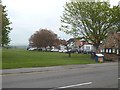

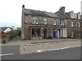
Please click the More button for more images, licensing and image copyright information.
Member of UK Parliament
This postcode is in the East Lothian parliamentary constituency.
East Lothian is a constituency in Scotland. The seat has been held by Kenny MacAskill (Alba Party) since December 2019.

Most Recent House Sales for Main Street, EH31 2AR
No recorded house sales or transfers for this postcode.
Local Petrol Station Prices
Coordinates for EH31 2AR
Sunrise and Sunset at EH31 2AR
Traffic Emission and Congestion Zones
Historical Weather Summary
| Clear | 7.63% |
| Cloudy | 38.58% |
| Rain | 8.33% |
| Windy | 45.46% |
| Other | 0.00% |
Average Energy Performance
Companies Registered at EH31 2AR
Postcode Details for EH31 2AR
Recent Updates
|
18 Apr 2024 Added Traffic Camera Views from Traffic Scotland to Roadworks within Scotland |
|
15 Apr 2024 Schools Data updated for April 2024 |
|
10 Apr 2024 Companies Data updated for March 2024 |
|
7 Apr 2024 New option to receive automatic updates to roadworks that affect you |
|
7 Apr 2024 Police and Crime data updated for February 2024 |
|
3 Apr 2024 Sold House Price data updated for February 2024 |
|
30 Mar 2024 Energy Performance Certificates (England and Wales) updated February 2024 |
|
28 Mar 2024 New feature to use Geolocating functions to detect your current location |
Random Postcodes
Want an idea of what is in our extensive website? Try somewhere completely random!
The Rural/Urban classification is based upon data collected during the 2011 Census and released in August 2013 and is categorised into 6 distinct classes.
[A] Urban Major conurbation: A built up area with a population of 10,000 (3,000 in Scotland) or more and is assigned to the major conurbation settlement category.
[B] Urban Minor conurbation: A built up area with a population of 10,000 (3,000 in Scotland) or more and is assigned to the minor conurbation settlement category.
[C] Urban City and town: A built up area with a population of 10,000 (3,000 in Scotland) or more and is assigned to the city and town settlement category.
[D] Rural Town and fringe
[E] Rural Village
[F] Rural Hamlet and isolated dwelling
The Index of Multiple Deprivation (IMD) is the official measure of relative deprivation.
The index is based on 39 separate indicators across seven distinct domains (Income; Employment; Health and Disability; Education, Skills and Training; Crime; Barriers to Housing and Services; Living Environment) to provide an overall measure of multiple deprivation and is calculated for every neighbourhood.
The index is relative rather than an absolute scale and so a neighbourhood with a score of 10 is more deprived than one rated 20, but this does not equate to being twice as deprived.
Please note: Different indices are used in England, Scotland, Wales and Northern Ireland and so comparison of scores from neighbourhoods in different countries should not be undertaken.
These figures report on incorporated UK companies only that are registered at this postcode and do not include sole-traders, partnerships or overseas organisations.
The population figure shown for your area are an estimate provided by the Office for National Statistics and is rounded to the nearest 1,000.
The estimates are derived from the Annual Population Survey (APS) which is the Labour Force Survey (LFS) plus various sample boosts.
There are 55 unitary authorities. They provide all local government services in their areas. These are mainly in the cities, urban areas and larger towns although there are now 6 shire county councils that are unitary (ie have no district councils beneath them).