
Alloa Station Junction
Introduction
The photograph on this page of Alloa Station Junction by A-M-Jervis as part of the Geograph project.
The Geograph project started in 2005 with the aim of publishing, organising and preserving representative images for every square kilometre of Great Britain, Ireland and the Isle of Man.

There are currently over 7.5m images from over 14,400 individuals and you can help contribute to the project by visiting https://www.geograph.org.uk
Alloa Station Junction
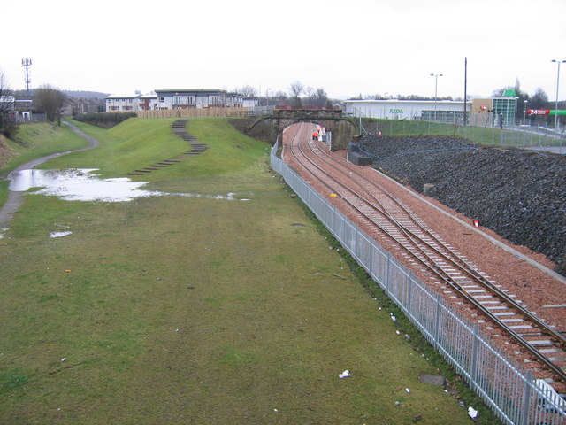
Image: © A-M-Jervis Taken: 11 Mar 2008
Forty years ago and earlier this photograph could have been taken from the booking office of Alloa railway station. In fact the camera was balanced on the parapet of Erskine Street bridge, which is now closed to vehicles but retained for pedestrians. Until October 1968 (and for a decade or so afterwards until their total demolition) the platforms of Alloa railway station passed under the bridge and passengers would have descended stairs from the booking office to the platform. The present railway station at Alloa, opened in May 2008, is just beyond the bridge in the distance on the newly re-laid line from Stirling to Kincardine. The green dip to the left, with a partly flooded footpath disappearing round it, was the course of the Devon Valley railway to Dollar and Kinross, which lost its passenger services in 1964. The bridge and embankment with steps coming down from it, mark the course of the Earl of Mar's waggonway, opened in 1766 and used until 1924, from coal pits in the Sauchie area down to Alloa Harbour. Today its route through the town is maintained as a footpath. Forty years ago as well, the site of the flat-roofed apartments behind the brown fence was occupied by a locomotive depot and where the Asda supermarket is now was a lager brewery.
Images are licensed for reuse under creativecommons.org/licenses/by-sa/2.0
Image Location

Latitude
56.118017
Longitude
-3.789744