
Rateen Farmhouse, Mount Sedborough
Introduction
The photograph on this page of Rateen Farmhouse, Mount Sedborough by D Gore as part of the Geograph project.
The Geograph project started in 2005 with the aim of publishing, organising and preserving representative images for every square kilometre of Great Britain, Ireland and the Isle of Man.

There are currently over 7.5m images from over 14,400 individuals and you can help contribute to the project by visiting https://www.geograph.org.uk
Rateen Farmhouse, Mount Sedborough
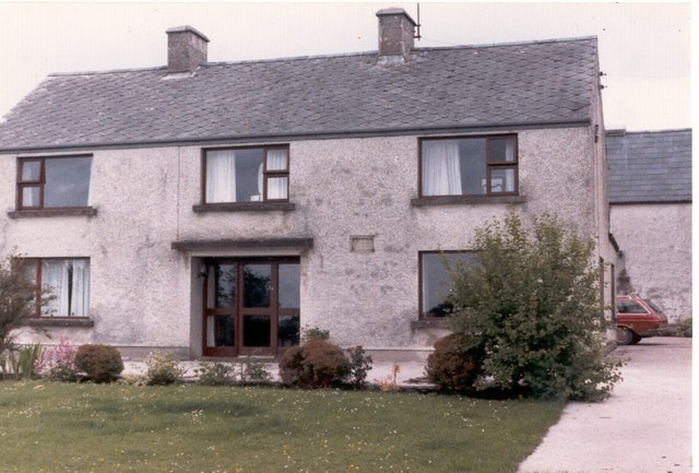
Image: © D Gore Taken: Unknown
Rateen is one of the farms on the property known as Mount Sedborough which in 1613 consisted of 1000 acres in the Barony of Clankelly between Ballagh and Derrynawilt (access today is from the B38 road). The land was granted in 1613 to John Sedborough of Porlock, Somerset,one of the "undertakers" in the settlement of Ulster. On John's death in 1629, Mount Sedborough came to his granddaughter Barbara, the wife of John Mayne. On Tuesday 26th October 1641, John Mayne was murdered on his land in front of his wife and children by local Irish under Rory MacGuire during the rebellion of that year http://books.google.co.uk/books?id=2_ZstVBZSfIC&lpg=PA1&pg=PA108#v=onepage&q=&f=true . Since that time the Mayne family have retained Mount Sedborough which they still farm, but the memory of the murder persisted in the family who looked on Tuesday as a day of ill omen right into the 19th century. Rateen farmhouse, pictured here, was built in 1809 by Samuel Mayne (1768-1844). In 1798 he was himself attacked by Irish rebels but was able to beat them off. The other Mayne farmhouse on Mount Sedborough is Image
Images are licensed for reuse under creativecommons.org/licenses/by-sa/2.0
Image Location

Latitude
54.220987
Longitude
-7.321147