St Andrew's church - C17 memorial
Introduction
The photograph on this page of St Andrew's church - C17 memorial by Evelyn Simak as part of the Geograph project.
The Geograph project started in 2005 with the aim of publishing, organising and preserving representative images for every square kilometre of Great Britain, Ireland and the Isle of Man.

There are currently over 7.5m images from over 14,400 individuals and you can help contribute to the project by visiting https://www.geograph.org.uk
St Andrew's church - C17 memorial
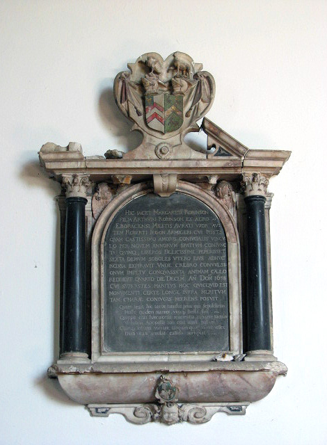
Image: © Evelyn Simak Taken: 1 Jul 2008
Alabaster monument with black marble columns, to Margaret Robinson (d. 1638). St Andrew's church > http://www.geograph.org.uk/photo/867209 - http://www.geograph.org.uk/photo/867224 - http://www.geograph.org.uk/photo/867363 was extensively restored, with the tower and part of the rest of the church rebuilt, by architect J.B. Pearce during the 19th century. Piscina and sedilia date from the 13th century. Part of the original C16 rood screen > http://www.geograph.org.uk/photo/867348 was moved and now separates the chancel from the south aisle; there are some interesting C17 and C18 wall monuments > http://www.geograph.org.uk/photo/867358 and ledger stones > http://www.geograph.org.uk/photo/867369. The glass in the south aisle east window > http://www.geograph.org.uk/photo/867342 is by Thomas Willement (c. 1859). The east window > http://www.geograph.org.uk/photo/867338 is by Charles Clutterbuck (1858). The church is open every day. For more information see: http://www.norfolkchurches.co.uk/buxton/buxton.htm
Images are licensed for reuse under creativecommons.org/licenses/by-sa/2.0
Image Location
Latitude
52.756079
Longitude
1.308284