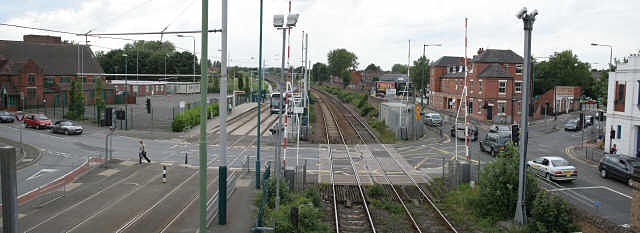
David Lane Crossing
Introduction
The photograph on this page of David Lane Crossing by Alan Murray-Rust as part of the Geograph project.
The Geograph project started in 2005 with the aim of publishing, organising and preserving representative images for every square kilometre of Great Britain, Ireland and the Isle of Man.
There are currently over 7.5m images from over 14,400 individuals and you can help contribute to the project by visiting https://www.geograph.org.uk

Image: © Alan Murray-Rust Taken: 24 Jun 2008
Panoramic view from the footbridge showing the complexity of the crossing. It comprises a rail crossing, a tram crossing and a normal traffic light controlled crossroads. From a signalling point of view it is probably the most complex road junction in the UK. The normal traffic signals have to be integrated with the railway and the tramway signalling systems, both of which have their own characteristics. As part of the reconstruction of the crossing for the tramway, all the right or left turns at the main road crossing were removed. There is a link road round the back of the red brick building which allows all the necessary manoeuvres to take place, so that the crossroads is very simple. For trains to pass, there are the normal twin flashing red lights as well as the barriers, but additionally the traffic lights are changed to red for the left-right traffic. The stop line to the left is sited far enough away to allow trams also to pass when the road traffic is stopped.The main road traffic retains a green phase for as long as the rail crossing is closed. When the rail barriers are open, the crossing works on a normal phasing pattern. Within this pattern, trams get a proceed signal when the traffic lights are red for the crossing traffic. Nottingham's first generation of electric trams ran along Vernon Road, the main road alongside the railway, later being replaced by trolleybuses. Panoramic view from three separate images.
Image Location


