Information board, Articlave
Introduction
The photograph on this page of Information board, Articlave by Kenneth Allen as part of the Geograph project.
The Geograph project started in 2005 with the aim of publishing, organising and preserving representative images for every square kilometre of Great Britain, Ireland and the Isle of Man.

There are currently over 7.5m images from over 14,400 individuals and you can help contribute to the project by visiting https://www.geograph.org.uk
Information board, Articlave
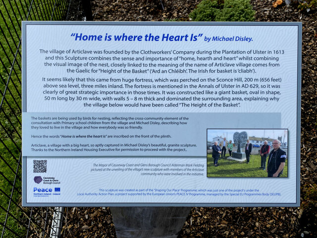
Image: © Kenneth Allen Taken: 24 Aug 2024
Ther following text is included: "Home is where the Heart Is" by Michael Disley. The village of Articlave was founded by the Clothworkers' Company during the Plantation of Ulster in 1613 and this Sculpture combines the sense and importance of "home, hearth and heart" whilst combining the visual image of the nest, closely linked to the meaning of the name of Articlave village comes from the Gaelic for "Height of the Basket" ('Ard an Chléibh. The Irish for basket is 'cliabh'). It seems likely that this came from huge fortress, which was perched on the Sconce Hill, 200 m (656 feet) above sea level, three miles inland. The fortress is mentioned in the Annals of Ulster in AD 629, so it was clearly of great strategic importance in those times. It was constructed like a giant basket, oval in shape, 50 m long by 30 m wide, with walls 5 - 8 m thick and dominated the surrounding area, explaining why the village below would have been called "The Height of the Basket". Pictured here Image]
Images are licensed for reuse under creativecommons.org/licenses/by-sa/2.0
Image Location
Latitude
55.145648
Longitude
-6.772605