Old Boundary Marker by the A58, Wigan Road
Introduction
The photograph on this page of Old Boundary Marker by the A58, Wigan Road by C Leather as part of the Geograph project.
The Geograph project started in 2005 with the aim of publishing, organising and preserving representative images for every square kilometre of Great Britain, Ireland and the Isle of Man.

There are currently over 7.5m images from over 14,400 individuals and you can help contribute to the project by visiting https://www.geograph.org.uk
Old Boundary Marker by the A58, Wigan Road
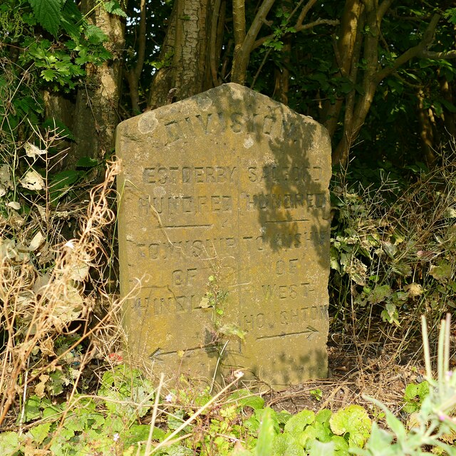
Image: © C Leather Taken: 17 Aug 2024
Township Boundary Marker in a hedge on the northwest side of the A58 Wigan Road 200 metres west of Gregory Road. On the former boundary of Hindley and Westhoughton parishes. Hindley parish became part of the Wigan unparished area in 1974. Inscribed DIVISION at the top, (W)EST / DERBY / HUNDRED / (line) / TOWNSHIP / OF HINDLEY / (arrow) on the left, and SALFORD / HUNDRED / (line) / TOWNSHIP / OF / WEST- / HOUGHTON / (arrow) on the right, separated by a vertical line. See also https://www.geograph.org.uk/photo/6037634. Milestone Society National ID: LA_BOWG07pb
Images are licensed for reuse under creativecommons.org/licenses/by-sa/2.0
Image Location
Latitude
53.541597
Longitude
-2.560448