Entrance to the railway dive under at Werrington Junction
Introduction
The photograph on this page of Entrance to the railway dive under at Werrington Junction by Paul Bryan as part of the Geograph project.
The Geograph project started in 2005 with the aim of publishing, organising and preserving representative images for every square kilometre of Great Britain, Ireland and the Isle of Man.

There are currently over 7.5m images from over 14,400 individuals and you can help contribute to the project by visiting https://www.geograph.org.uk
Entrance to the railway dive under at Werrington Junction
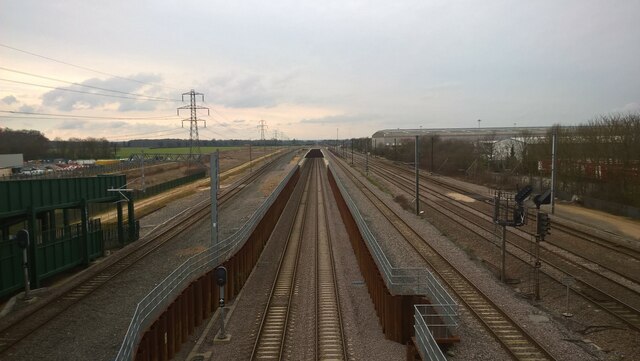
Image: © Paul Bryan Taken: 3 Mar 2024
The reconfigured track layout, known as the Werrington Grade Separation Plan, is seen here from the footbridge linking the A15 Werrington Parkway and Dukesmead with Stirling Way. The plan involved the construction of a new connection between the Stamford Lines and the Great Northern Great Eastern (GNGE) line. Hitherto, trains joining or leaving the GNGE here were obliged to cross the East Coast Main Line (ECML), resulting in delays and bottlenecks. The Grade Separation Plan provided for a new three-kilometre line including an underpass (or "dive under") enabling trains to pass underneath the ECML. The tracks which pass through the "dive under" can be seen in the centre of the image. They rejoin the existing Peterborough to Lincoln section of the GNGE line at Glinton Junction, as it is designated by Network Rail from the name of the neighbouring village. Work on the project, which cost a total of £200 million, commenced in the summer of 2018. The tunnel itself was created in January 2021 by pushing a curved concrete box weighing in excess of 11,000 tonnes and measuring 510 feet (155 metres) in length under the ECML with the aid of hydraulic jacks. The tunnel had been prefabricated in nine separate sections prior to installation. This represented the first time that this particular construction technique had been employed in the United Kingdom. The "dive under" - which formed part of a £1.2 billion upgrade of the ECML - was formally inaugurated by the then Minister of State for Transport Chris Heaton-Harris on December 9th., 2021. The Royal Mail building on the right of the image is the Peterborough Delivery Office and Mail Centre, which is the main sorting office for the PE post code area. Sources: https://www.bbc.co.uk/news/av/uk-england-cambridgeshire-55680675 https://www.bbc.co.uk/news/uk-england-cambridgeshire-59578414 https://en.wikipedia.org/wiki/Werrington_Dive_Under https://www.networkrail.co.uk/running-the-railway/our-routes/east-coast/east-coast-upgrade/werrington-grade-separation/ https://www.theconstructionindex.co.uk/news/view/morgan-sindall-mobilises-for-200m-werrington-dive-under
Images are licensed for reuse under creativecommons.org/licenses/by-sa/2.0
Image Location
Latitude
52.611837
Longitude
-0.286769