Old Milestone by the A6114, Harry Potts Way, Burnley
Introduction
The photograph on this page of Old Milestone by the A6114, Harry Potts Way, Burnley by Nigel Upton as part of the Geograph project.
The Geograph project started in 2005 with the aim of publishing, organising and preserving representative images for every square kilometre of Great Britain, Ireland and the Isle of Man.

There are currently over 7.5m images from over 14,400 individuals and you can help contribute to the project by visiting https://www.geograph.org.uk
Old Milestone by the A6114, Harry Potts Way, Burnley
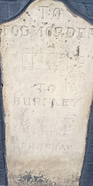
Image: © Nigel Upton Taken: 30 Sep 2022
Carved stone post by the A6114, in parish of Burnley (Burnley District), Harry Potts Way (formerly Todmorden Road), Burnley; 30m East of Duck & Boot PH (now demolished), built into wall of football stadium. Todmorden roll-top, erected by the Todmorden turnpike trust in the 19th century. An earlier photograph can be found here https://www.geograph.org.uk/photo/6098013. Inscription reads:- TO TODMORDEN {hand->} 9 TO BURNLEY ¼ {<-hand} BRUNSHAW Grade II listed. List Entry Number: 1022636 https://historicengland.org.uk/listing/the-list/list-entry/1022636 Milestone Society National ID: LA_BUTO00
Images are licensed for reuse under creativecommons.org/licenses/by-sa/2.0
Image Location
Latitude
53.788718
Longitude
-2.232315