
Icknield Street Board School, Birmingham
Introduction
The photograph on this page of Icknield Street Board School, Birmingham by A J Paxton as part of the Geograph project.
The Geograph project started in 2005 with the aim of publishing, organising and preserving representative images for every square kilometre of Great Britain, Ireland and the Isle of Man.

There are currently over 7.5m images from over 14,400 individuals and you can help contribute to the project by visiting https://www.geograph.org.uk
Icknield Street Board School, Birmingham
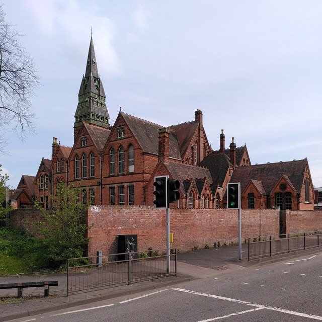
Image: © A J Paxton Taken: 22 Apr 2023
The school was built in 1883 to designs by Martin & Chamberlain, architects of many of the Board Schools built by Birmingham Corporation following the passing of the Elementary Education Act of 1870. The architect John Henry Chamberlain (who was not related to the mayor, Joseph Chamberlain) believed strongly that schools should provide a healthy, beautiful and uplifting environment for children who lived in the drab, polluted and often slummy conditions of the industrial city. This is reflected in the spacious and soaring Gothic architecture and the in the tower and louvred spire, which were designed to draw in cleaner air from well above ground level; see Wikipedia on the Birmingham Board Schools https://en.wikipedia.org/wiki/Birmingham_board_school , also the Historic England site for a description of this Grade II* listed building https://historicengland.org.uk/listing/the-list/list-entry/1076315?section=official-list-entry. The school, or at least its ground floor, appears to be in use as a Hindu temple. In 2021 the Victorian Society listed it as one of their Top Ten Endangered Buildings for that year on account of water damage to the upper storeys https://www.victoriansociety.org.uk/news/top-ten-endangered-buildings-2021-icknield-street-school-birmingham-grade-ii-listed-by-jh-chamberlain-of-martin-and-chamberlain-1883.
Images are licensed for reuse under creativecommons.org/licenses/by-sa/2.0
Image Location

Latitude
52.49411
Longitude
-1.916002