Brandy Bottom Colliery - beam winding engine house
Introduction
The photograph on this page of Brandy Bottom Colliery - beam winding engine house by Chris Allen as part of the Geograph project.
The Geograph project started in 2005 with the aim of publishing, organising and preserving representative images for every square kilometre of Great Britain, Ireland and the Isle of Man.

There are currently over 7.5m images from over 14,400 individuals and you can help contribute to the project by visiting https://www.geograph.org.uk
Brandy Bottom Colliery - beam winding engine house
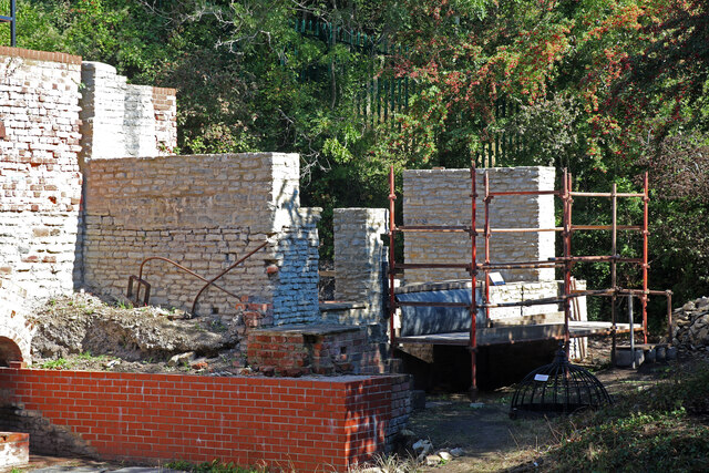
Image: © Chris Allen Taken: 10 Sep 2022
This Scheduled Ancient Monument is on the South Gloucestershire Coalfield in the parish of Pucklechurch. The first pits on site date back to around 1837 although the name Brandy Bottom is first noted in 1856. A new pit was sunk in 1871 and is separated from the complex of buildings represented by this engine house. Coal drawing at Brandy Bottom ceased before WWI and the pit was then used to ventilate another nearby mine. All operations ceased in 1936. This engine house belongs to the old pit and could therefore date to about 1837. It is described on the website as the 'vertical engine house' but quite clearly contained a rotative beam engine. Seen during a tour on Heritage Open Day. An auction catalogue of 1900 describes what may well have been the engine in this house: - Old Pit winding engine - Condensing winding engine, 24 inch cylinder, 4 foot 6 inch stroke, 2 gearing wheels, fly wheels, barrel drum 13 feet diameter, 380 yards 1 1/8 inch steel wire rope, wrought iron cage 6 cwts. Head gear 13 feet pulley wheel. Pit bank 40 feet by 40 feet. The red brick wall represents one side of the flue from the boilers to the chimney that is built on the pit bank.
Images are licensed for reuse under creativecommons.org/licenses/by-sa/2.0
Image Location


Leaflet Map data © OpenStreetMap
Latitude
51.492396
Longitude
-2.458856