Seaside Information Board, Eastbourne
Introduction
The photograph on this page of Seaside Information Board, Eastbourne by David Hillas as part of the Geograph project.
The Geograph project started in 2005 with the aim of publishing, organising and preserving representative images for every square kilometre of Great Britain, Ireland and the Isle of Man.

There are currently over 7.5m images from over 14,400 individuals and you can help contribute to the project by visiting https://www.geograph.org.uk
Seaside Information Board, Eastbourne
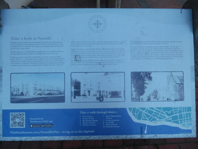
Image: © David Hillas Taken: 28 Sep 2022
This information board has been provided by the East of the Pier Heritage Trust and is located in Sea Houses Square between Marine Parade and Seaside. It has the following wording: Take a look at Seaside Left column Standing with your back to the sea, Seaside is the main road in front of you. It was managed by a toll company until 1872 when it was handed over to the Local Board. It runs along the north edge of the shingle bank and this is the reason for the steep camber. Directly opposite is a listed building originally known as the Ballroom House because the local garrison used it as assembly rooms for social events. Further east on the same side you will find a fine terrace, also listed. This houses 'Charlie's', a youth facility that has taken its name from Charles Jewell a well known philanthropist. Jewell made his fortune in the early 1900s as a beef farmer in Argentina. Following his retirement to Eastbourne he funded a number of large parties and outings for poor children from the town's east Image of Metropole Court in Royal Parade BN22 7AX Middle column end. Just prior to his death in 1922 he set up an organisation to educate young women and to help them find employment. In 1959 a youth club was funded from the proceeds of his trust. Opposite 'Charlie's' is the Leaf Hall. Built in 1864 for the improvement of the working man, it plays host to a History Corner that you are welcome to visit. It was the first public hall to be built in the town and so was used for a variety of entertainment, lectures and meetings. Times were particularly hard in the 1880s and it was a key point for the distribution of food and fuel to the poor. The drinking fountain in this Square was originally located in the middle of the road outside the Leaf Hall. It was donated by Mrs Curling in response to a serious outbreak of Scarlet Fever in 1863 when many children died. Image of the drinking fountain in Seaside opposite Leaf Hall. Right column Poor quality water was blamed. The fountain soon became a popular meeting point for the area and was known as 'Speakers' Corner'. It was in this vicinity that slipper baths were built in 1902 - the first real investment of public funds in the neighbourhood. You paid 6d (2.5p) for a bath in a cubicle and the taps were controlled remotely by an attendant. A wash and brush up for 1s (5p) was available for visitors to the town who were only staying a week and so did not have need of a bath. Another History Corner is available a few hundred yards further east at Christ Church, or if you turn west towards the town centre there is one at the Hippodrome Theatre. Image of Leaf Hall in Seaside, BN22 7NB Lower section Street map of 'Take a walk through history' with the following numbered items marked on it 1) Pier Gardens 2) Marine Parade 3) Sea Houses Square 4) Marine Gardens 5) Pavilion Gardens 6) Royal Hippodrome Theatre 7) Crown & Anchor 8) Leaf Hall 9) Christ Church 10) Redoubt Fortress
Images are licensed for reuse under creativecommons.org/licenses/by-sa/2.0
Image Location
Latitude
50.769795
Longitude
0.294755