Penfold postbox, Beeches Avenue
Introduction
The photograph on this page of Penfold postbox, Beeches Avenue by Ian Capper as part of the Geograph project.
The Geograph project started in 2005 with the aim of publishing, organising and preserving representative images for every square kilometre of Great Britain, Ireland and the Isle of Man.

There are currently over 7.5m images from over 14,400 individuals and you can help contribute to the project by visiting https://www.geograph.org.uk
Penfold postbox, Beeches Avenue
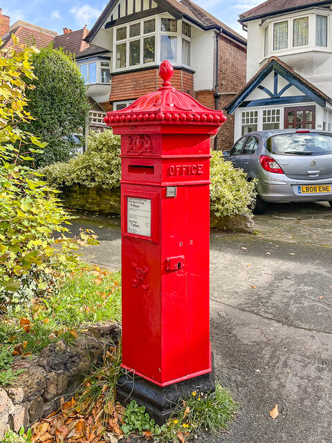
Image: © Ian Capper Taken: 7 Oct 2022
A Penfold postbox outside 56 Beeches Avenue. These distinctive hexagonal boxes were manufactured by Cochrane & Co of Dudley in Worcestershire between 1866 and 1879, to a design of John Penfold, hence the name. Although there is no suggestion that this example is not an original box (as opposed to a replica), it would not appear to be in its original position. The houses along this stretch of Beeches Avenue are first marked on the 1913 25 inch map, which is consistent with their Edwardian design, and although the road (marked on that map as The Beeches rather than its current name) is also shown on earlier maps it was largely undeveloped - for example the 1895 25 inch map shows it (then marked as Beechnut Tree Road) with only a farm (Barrowhedges Farm) accessed opposite this point and a large house (Barrow Hedges) further south. Neither map marks a postbox at this point, although the 1913 map shows one further north along the road. It is not until the 1935 edition (when the road was named The Beeches Avenue) that a box is shown at this point (but not the one further north). This is some 50+ years after the box would have been manufactured, hence my suggestion that the site is not original. Grade II listed - see https://historicengland.org.uk/listing/the-list/list-entry/1357565?section=official-list-entry. For a wider view see Image
Images are licensed for reuse under creativecommons.org/licenses/by-sa/2.0
Image Location
Latitude
51.354499
Longitude
-0.171163