"Stop Line Green" pillbox at Upper Framilode
Introduction
The photograph on this page of "Stop Line Green" pillbox at Upper Framilode by Roger Davies as part of the Geograph project.
The Geograph project started in 2005 with the aim of publishing, organising and preserving representative images for every square kilometre of Great Britain, Ireland and the Isle of Man.

There are currently over 7.5m images from over 14,400 individuals and you can help contribute to the project by visiting https://www.geograph.org.uk
"Stop Line Green" pillbox at Upper Framilode
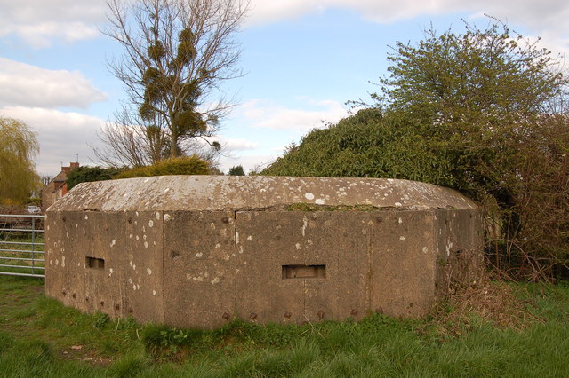
Image: © Roger Davies Taken: 18 Mar 2008
Standing insignificantly in a field just south of the junction of the river Frome with the river Severn is this prefabricated WW2 'thick-walled' type 24 pillbox. In 1940 it formed the most northerly point of "Stop Line Green" also called the "Bristol Outer Defence". This was a continuous defensive barrier running for some 100 miles in a wide arc to the east of Bristol all the way from Highbridge on the Bristol Channel to this pillbox position in Upper Framilode. The defensive line assumed that a German invasion (Operation Sealion) had been successful to the south and east but strategically hoped to use the port of Bristol to resupply the defenders of pillboxes such as this one and ideally to mount a successful counter-attack.
Images are licensed for reuse under creativecommons.org/licenses/by-sa/2.0
Image Location
Latitude
51.788734
Longitude
-2.359937